IMAGES TAKEN NEAR TO
Dashpers, BRIXHAM, TQ5 9LG
Introduction
This page details the photographs taken nearby to Dashpers, TQ5 9LG by members of the Geograph project.
The Geograph project started in 2005 with the aim of publishing, organising and preserving representative images for every square kilometre of Great Britain, Ireland and the Isle of Man.

There are currently over 7.5m images from over14,400 individuals and you can help contribute to the project by visiting https://www.geograph.org.uk
Image Map
Images are licensed for reuse under creativecommons.org/licenses/by-sa/2.0
Notes
- Clicking on the map will re-center to the selected point.
- The higher the marker number, the further away the image location is from the centre of the postcode.
Image Listing (64 Images Found)
Images are licensed for reuse under creativecommons.org/licenses/by-sa/2.0
Image
Details
Distance
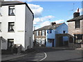
1
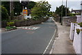
Horsepool Street, Brixham
Heading Northwest towards Monksbridge Road.
Image: © jeff collins
Taken: 17 Jun 2015
0.04 miles
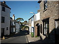
2
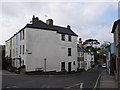
Brixham : Horsepool Street
Looking along Horsepool Street.
Image: © Lewis Clarke
Taken: 10 Nov 2020
0.05 miles
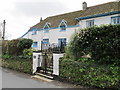
3
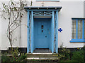
Front door of Hill House, Brixham
The house is now a nursing home. See Image for description of the house.
Image: © David Hawgood
Taken: 25 Feb 2011
0.06 miles
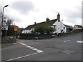
4
Horsepool Street, Higher Brixham
Opposite the Waterman's Arms. The name of the street no doubt signifies its use in the past, as a small stream flows down to Lower Brixham
Image: © Tom Jolliffe
Taken: 15 Mar 2007
0.07 miles
7
Hill House, Brixham, showing front wall and gate piers.
The house is listed grade II, and the listing includes the front wall and gate piers. See Image for more information.
Image: © David Hawgood
Taken: 25 Feb 2011
0.08 miles
8
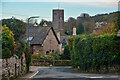
Hill House, Higher Brixham
This house certainly dates from at least the 16th Century, and is thought to date from the 13th Century. It is now a nursing home. It is on Horsepool Road (to the left in the photo) at the junction with Mathill road (going up to the right). In about 1840 it was bought by Henry Chilcote after the death of his father, Rev. Joseph Chilcote, vicar of Dean Prior and rector of Thurleston. There are several memorials to the Chilcote family in St Mary's church nearby, and an obelisk in St. Marychurch is a memorial to Joseph's grandson Herbert Nicholas Chilcote MRCS - see Image
Image: © David Hawgood
Taken: 25 Feb 2011
0.08 miles
9
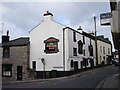
The Waterman's Arms, Drew Street, Brixham
A popular pub in the heart of Higher Brixham, near to St Mary's Church.
Image: © Tom Jolliffe
Taken: 15 Mar 2007
0.08 miles
10
Brixham : Mathill Road
Looking along Mathill Road.
Image: © Lewis Clarke
Taken: 10 Nov 2020
0.08 miles