IMAGES TAKEN NEAR TO
Victoria Road, BRIXHAM, TQ5 9AR
Introduction
This page details the photographs taken nearby to Victoria Road, TQ5 9AR by members of the Geograph project.
The Geograph project started in 2005 with the aim of publishing, organising and preserving representative images for every square kilometre of Great Britain, Ireland and the Isle of Man.

There are currently over 7.5m images from over14,400 individuals and you can help contribute to the project by visiting https://www.geograph.org.uk
Image Map
Images are licensed for reuse under creativecommons.org/licenses/by-sa/2.0
Notes
- Clicking on the map will re-center to the selected point.
- The higher the marker number, the further away the image location is from the centre of the postcode.
Image Listing (109 Images Found)
Images are licensed for reuse under creativecommons.org/licenses/by-sa/2.0
Image
Details
Distance
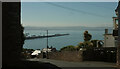
1
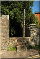
Stile, Victoria Road, Brixham
Onto footpath BX 2, along which a shadowy figure can be seen. Also visible in Image
Image: © Derek Harper
Taken: 13 Jun 2021
0.02 miles
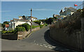
2
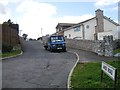
Victoria Road, Brixham
A sharp left bend in the road, where footpath BX 2 leaves on the right via a stone stile.
Image: © Derek Harper
Taken: 13 Jun 2021
0.02 miles
4
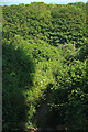
Footpath to Berry Head Farm
Footpath BX 2 plunges down into a wooded valley.
Image: © Derek Harper
Taken: 13 Jun 2021
0.04 miles
5
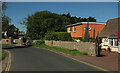
Victoria Road, Brixham
The view round the bend shown in Image], with the road dropping steeply to meet Berry Head Road.
Image: © Derek Harper
Taken: 13 Jun 2021
0.04 miles
6
Victoria Road, Brixham
Seen across its junction with Berry Head Road.
Image: © Derek Harper
Taken: 30 Jul 2024
0.06 miles
7
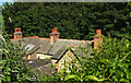
Berry Head Cottages
Seen, with a little difficulty, from the footpath shown in Image
Image: © Derek Harper
Taken: 13 Jun 2021
0.06 miles
8
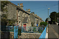
Listed cottages, Berry Head Road
A listed terrace https://historicengland.org.uk/listing/the-list/list-entry/1298256?section=official-list-entry . "5 linked pairs of semi-detached cottages, originally built for coastguards. c1889. Squared rough-faced Devonian limestone rubble ... in front of the whole range of houses is a low stone wall having a chamfered limestone coping and an iron railing with simple pointed uprights. Nos 14-20 & 24 have gates to match".
The blue plaque shown in Image is towards the end of this row. To the left of the camera is the separately-listed Image
Image: © Derek Harper
Taken: 30 Jul 2024
0.07 miles
9
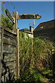
Footpath signpost, Berry Head Farm
Showing the route of footpaths BX 3 (right) and 2 (behind camera). Unfortunately there are two other paths ahead to the left, one of which I had planned to take, but my wife had followed the signpost to the right (I'm always behind her taking photographs for some reason), which leads eventually back the way we had come. In the background is the farmhouse and a barn.
Image: © Derek Harper
Taken: 13 Jun 2021
0.07 miles
10
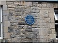
Blue Plaque for Jim Callaghan in Brixham
The plaque marks the home of Prime Minister James Callaghan from 1914 to 1922. Unfortunately, there are so many lines of text that it is hard to read from the pavement in front of the building.
Image: © David Smith
Taken: 31 Aug 2012
0.07 miles