IMAGES TAKEN NEAR TO
Bascombe Road, BRIXHAM, TQ5 0JH
Introduction
This page details the photographs taken nearby to Bascombe Road, TQ5 0JH by members of the Geograph project.
The Geograph project started in 2005 with the aim of publishing, organising and preserving representative images for every square kilometre of Great Britain, Ireland and the Isle of Man.

There are currently over 7.5m images from over14,400 individuals and you can help contribute to the project by visiting https://www.geograph.org.uk
Image Map (Loading...)


Getting Data...Please wait
Leaflet Map data © OpenStreetMap
Images are licensed for reuse under creativecommons.org/licenses/by-sa/2.0
Notes
- Clicking on the map will re-center to the selected point.
- The higher the marker number, the further away the image location is from the centre of the postcode.
Image Listing (83 Images Found)
Images are licensed for reuse under creativecommons.org/licenses/by-sa/2.0
Image
Details
Distance
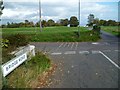
1
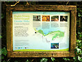
Global Geopark information board
I was hoping to find this map on the internet, but have so far failed to do so.
Image: © Derek Harper
Taken: 9 Dec 2020
0.04 miles
2
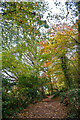
Churston Ferrers : Footpath
Looking along a footpath.
Image: © Lewis Clarke
Taken: 10 Nov 2020
0.05 miles
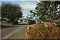
3
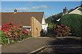
Path, Brunel Road, Broadsands
See Image]; this looks along the path mentioned from the cul-de-sa. The dog bin is visible on Elberry Lane.
Image: © Derek Harper
Taken: 21 Oct 2021
0.06 miles
4
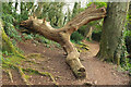
Fallen tree, Marridge Wood
Impressively weathered, this is on the Greenway Walk.
Image: © Derek Harper
Taken: 20 Mar 2022
0.06 miles
5
Orange Way in Devon and Torbay (12)
This view is towards Churston Golf Club and Eberry Cove.
Image: © Shazz
Taken: 16 Oct 2011
0.06 miles
6
Brunel Road, Broadsands
Looking left from Image The monkey puzzle tree shown in Image] is on the right. On the left is the eastern junction with Lower Fowden.
Image: © Derek Harper
Taken: 21 Oct 2021
0.07 miles
7

Monkey puzzle tree, Brunel Road, Broadsands
An Araucaria bearing fruit, by the cul-de-sac where Image] was taken.
Image: © Derek Harper
Taken: 21 Oct 2021
0.07 miles
8
Elbury Lane
Elbury and Elberry seem interchangeable; the nearby cove and farm (the farmhouse is on the left), and the metalled part of the lane, are "Elberry", but the path that runs diagonally across this image (and shown in Image) is mapped as "Elbury Lane". This view is from the edge of Marrisge Wood. Tor Bay and parts of Paignton are in the background.
Image: © Derek Harper
Taken: 16 Jan 2012
0.07 miles
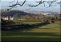
9
Elberry footpath, near Marridge Wood
View north towards Torbay. Today's footpath was originally the principal access road or track from Churston to Elberry Farm and Broadsands beach beyond. It meets the main coastal footpath at the trees, centre middle distance.
Image: © Crispin Purdye
Taken: 28 Sep 2003
0.07 miles
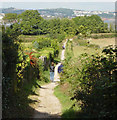
10
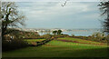
Field by Elberry Lane
A similar view to Image, with Tor Bay in the background. This is on a Global Geopark Circular Walk.
Image: © Derek Harper
Taken: 9 Dec 2020
0.07 miles