IMAGES TAKEN NEAR TO
Galmpton, BRIXHAM, TQ5 0ER
Introduction
This page details the photographs taken nearby to TQ5 0ER by members of the Geograph project.
The Geograph project started in 2005 with the aim of publishing, organising and preserving representative images for every square kilometre of Great Britain, Ireland and the Isle of Man.

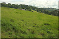
There are currently over 7.5m images from over14,400 individuals and you can help contribute to the project by visiting https://www.geograph.org.uk
Image Map
Images are licensed for reuse under creativecommons.org/licenses/by-sa/2.0
Notes
- Clicking on the map will re-center to the selected point.
- The higher the marker number, the further away the image location is from the centre of the postcode.
Image Listing (96 Images Found)
Images are licensed for reuse under creativecommons.org/licenses/by-sa/2.0
Image
Details
Distance
1
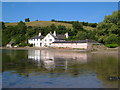
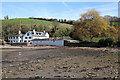
Galmpton Mill / Old Mill Farm
Both names appear on maps. At this point the Dart estuary reaches a mile in width. The exact line of the footpath past this lovely spot has been the subject of prolonged debate http://www.devon.gov.uk/doc-tunnel-4.pdf?url=/dcc/committee/reports/pdf/cs0521.pdf (149-page pdf doc, with numerous letters, maps, old photos and accounts of proceedings) This link can no longer be traced; https://democracy.devon.gov.uk/Data/Public%20Rights%20of%20Way%20Committee/20071011/Agenda/pdf-CS-05-21.pdf gives an overview and decision.
Image: © Derek Harper
Taken: 24 Jun 2006
0.01 miles
2
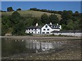
Galmpton Mill / Old Mill Farm
The view shown seven years earlier in Image, at a higher tide. The Greenway Walk follows Kingswear Footpath 52 around this foreshore, leaving it to the right of the outbuilding on the extreme left.
Image: © Derek Harper
Taken: 3 Sep 2013
0.01 miles
3
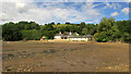
Old Mill Farm
As Tony points out at Image, not a mill, nor, really, a farm, though there are fields attached. Work is taking place on the central building.
Image: © Derek Harper
Taken: 6 Jun 2019
0.01 miles
4
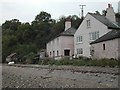
Old Mill Farm
As reported here: Image, the public footpath past the property has been the subject of heated dispute, including a successful challenge in the High Court: http://www.bailii.org/ew/cases/EWHC/Admin/2007/1209.html. At issue is whether the path leaves the foreshore to join the drive past the wooden waymark (just left of the ground floor window), or continues along the foreshore to join Mill Lane where it becomes a public road (about 30m further on). Just left of the waymark post is a notice suggesting walkers use the latter route.
Image: © Hugh Craddock
Taken: 22 Oct 2003
0.01 miles
5
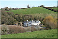
Field by Mill Lane
Looking left from the stretch of lane shown in Image], with a distant view of the model farm at Lower Greenway Image
Image: © Derek Harper
Taken: 6 Jun 2019
0.01 miles
6
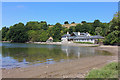
Kingswear: Old Mill Farm from the estuary
House conversion by the foreshore
Image: © Martin Bodman
Taken: 19 Mar 2008
0.01 miles
7
Galmpton Mill / Old Mill Farm
Old Mill Farm on the River Dart.
Image: © Wayland Smith
Taken: 22 Jul 2018
0.02 miles
8
Old Mill Farm
Seen across the outer section of Galmpton Creek. The Greenway Walk passes in front of the farm tide permitting. There is another route to Greenway avoiding this area and not affected by the tide.
Image: © jeff collins
Taken: 22 Jul 2015
0.02 miles
9
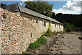
Outbuilding at Old Mill Farm, Galmpton
A similar view to Image, taken almost exactly ten years later. Kingswear Footpath 52 carries the Greenway Walk along the foreshore of the Dart.
Image: © Derek Harper
Taken: 6 Jun 2019
0.02 miles
10
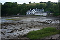
Kingswear: Old Mill Farm
Now a private residence. Seen from the public footpath from Lower Greenway
Image: © Martin Bodman
Taken: 19 Mar 2008
0.02 miles