IMAGES TAKEN NEAR TO
Southdown, BRIXHAM, TQ5 0AJ
Introduction
This page details the photographs taken nearby to TQ5 0AJ by members of the Geograph project.
The Geograph project started in 2005 with the aim of publishing, organising and preserving representative images for every square kilometre of Great Britain, Ireland and the Isle of Man.

There are currently over 7.5m images from over14,400 individuals and you can help contribute to the project by visiting https://www.geograph.org.uk
Image Map
Images are licensed for reuse under creativecommons.org/licenses/by-sa/2.0
Notes
- Clicking on the map will re-center to the selected point.
- The higher the marker number, the further away the image location is from the centre of the postcode.
Image Listing (13 Images Found)
Images are licensed for reuse under creativecommons.org/licenses/by-sa/2.0
Image
Details
Distance
1
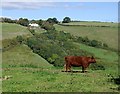
Cow on the Hilltop
Looking over the valley from Woodhuish Lane to Southdown Farm on the other side. I am no cattle expert but this looks like an example of a Red Ruby Devon, a breed of beef cattle.
Image: © Tony Atkin
Taken: 26 Sep 2010
0.04 miles
2
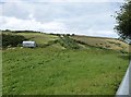
View from Woodhuish Lane up the hill to Southdown Barns
Woodhuish Lane is a path not recommended for vehicles that leads down to Man Sands beach.
Image: © Derek Voller
Taken: 11 Jul 2016
0.10 miles
3

Mansands Lane down to Mansands
Autumn leaves are dry and plentiful. This stone wall runs for a considerable distance alongside Mansands Lane.
Image: © Tom Jolliffe
Taken: 17 Oct 2008
0.11 miles
4

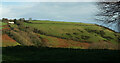
Southdown Hill, Brixham
Southdown Hill sits near the coast with Mansands on one side to the right in this photo and St Mary's Bay on the other. Residents' gardens are in the foreground.
Image: © Tom Jolliffe
Taken: 15 Oct 2013
0.14 miles
5

Mansands Lane down to Mansands
The steep Mansands Lane has been well maintained. There are ditches across the Lane lower down which prevent too much erosion. The valley can be seen over the wall.
Image: © Tom Jolliffe
Taken: 17 Oct 2008
0.14 miles
6

Mansands lane to Mansands
The Lane narrows as it descends towards the beach. Here there is a characteristic tangled mass of overhanging trees and bushes forming a tunnel. The leaves carpet the path.
Image: © Tom Jolliffe
Taken: 17 Oct 2008
0.15 miles
7
Hillside above Man Sands
Looking right from Image], with Southdown Farm on the left, and a hedge marking Mansands Lane as it drops to the right.
Image: © Derek Harper
Taken: 15 Nov 2020
0.15 miles
8

Footpath to Mansands
From time to time there are gates into the fields offering views across the valley.
Image: © Tom Jolliffe
Taken: 17 Oct 2008
0.17 miles
9
Field on Southdown Hill
Livestock at large on a hilltop field beside Southdown Road.
Image: © Derek Harper
Taken: 4 Sep 2011
0.17 miles
10
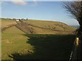
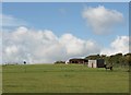
Southdown from Woodhuish Lane
Southdown is a hamlet just south of the built-up area of Brixham. The white building is Southdown Farm. The hill reaches the sea at Southdown Cliff on the right. The valley in between the hill and the camera reaches the sea at Man Sands. Taken from the same point as Image
Image: © Derek Harper
Taken: 30 Jan 2011
0.21 miles