IMAGES TAKEN NEAR TO
Dartmouth Road, PAIGNTON, TQ4 6NS
Introduction
This page details the photographs taken nearby to Dartmouth Road, TQ4 6NS by members of the Geograph project.
The Geograph project started in 2005 with the aim of publishing, organising and preserving representative images for every square kilometre of Great Britain, Ireland and the Isle of Man.

There are currently over 7.5m images from over14,400 individuals and you can help contribute to the project by visiting https://www.geograph.org.uk
Image Map
Images are licensed for reuse under creativecommons.org/licenses/by-sa/2.0
Notes
- Clicking on the map will re-center to the selected point.
- The higher the marker number, the further away the image location is from the centre of the postcode.
Image Listing (117 Images Found)
Images are licensed for reuse under creativecommons.org/licenses/by-sa/2.0
Image
Details
Distance
1
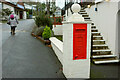
Disused postbox, Waterside Holiday Park
A George VI postbox provides a decorative feature; I hope there's not too much confusion.
Image: © Derek Harper
Taken: 1 Jan 2021
0.01 miles
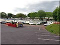
2
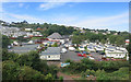
Waterside Holiday Park
Err...I'm not seeing much water here.
Image: © Des Blenkinsopp
Taken: 24 Aug 2016
0.02 miles
4
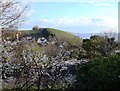
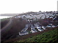
Blackthorn bush, Sugar Loaf, Paignton
The blackthorn bush grows at the roadside near to Sugar Loaf (the hill in the centre). In the valley below, there is a holiday camp with caravans and mobile homes, etc. In the distance, across the bay, Thatcher Rock is visible on the horizon.
Image: © Tom Jolliffe
Taken: 29 Mar 2009
0.05 miles
6
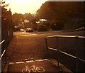
Waterside Road, near Three Beaches, Paignton
Just after the start of the dual carriageway on Dartmouth Road, this entry to Waterside Road enables the cyclist to avoid the heavy traffic which often plagues the road. However, one of the lanes on the aforesaid dual carriageway has now been reserved solely for buses and cyclists. Nonetheless, the Waterside Road route towards Brixham is quieter and more interesting. Before the dual carriageway of Dartmouth Road was blasted through the hillside, this was the old road to Brixham from Paignton. Older people may remember what must have been a tortuous route in the car. In this picture, the coastal promotory in the Brixham direction can just be made out on the horizon..
Image: © Tom Jolliffe
Taken: 28 Sep 2008
0.07 miles
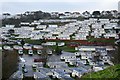
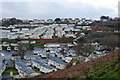
9
Mobile homes at Waterside Holiday Park
The railway on the left is the Paignton & Dartmouth Steam Railway.
Image: © Rod Allday
Taken: 22 Jan 2014
0.08 miles
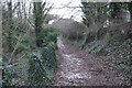
10
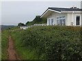
South West Coast Path passing holiday homes at Goodrington
Image: © David Smith
Taken: 26 Jun 2012
0.08 miles