IMAGES TAKEN NEAR TO
Blue Waters Drive, PAIGNTON, TQ4 6JE
Introduction
This page details the photographs taken nearby to Blue Waters Drive, TQ4 6JE by members of the Geograph project.
The Geograph project started in 2005 with the aim of publishing, organising and preserving representative images for every square kilometre of Great Britain, Ireland and the Isle of Man.

There are currently over 7.5m images from over14,400 individuals and you can help contribute to the project by visiting https://www.geograph.org.uk
Image Map
Images are licensed for reuse under creativecommons.org/licenses/by-sa/2.0
Notes
- Clicking on the map will re-center to the selected point.
- The higher the marker number, the further away the image location is from the centre of the postcode.
Image Listing (192 Images Found)
Images are licensed for reuse under creativecommons.org/licenses/by-sa/2.0
Image
Details
Distance
1
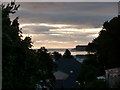
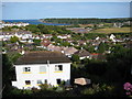
Waterside Road
The early morning light is reflected from the house windows and roofs on Waterside Road, which runs down to the Holiday camp. The Brixham promontory can be seen in the distance.
Image: © Tom Jolliffe
Taken: 19 Sep 2010
0.05 miles
2
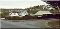
The Close, Broadsands
Not a terribly distinctive street name, one can't help feeling. The cul-de-sac is off Broadsands Park Road, itself a no through road.
Image: © Derek Harper
Taken: 1 Jan 2021
0.07 miles
4
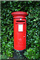
Postbox, Broadsands Park Road
Elizabeth II postbox TQ4 353 is at the top of the road by the junction with Blue Waters Drive.
Image: © Derek Harper
Taken: 1 Jan 2021
0.08 miles
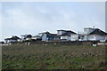
6
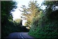
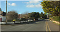
Waterside Road, Three Beaches, Torbay
The old road towards Brixham is far more suitable for the walker or cyclist than the dual carriageway.
Image: © Tom Jolliffe
Taken: 28 Sep 2008
0.10 miles
7
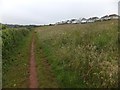
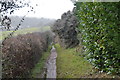
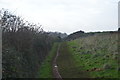
Wild flower meadow beside the South West Coast Path
The bungalows are on the edge of Goodrington. The path runs beside the Paignton and Dartmouth Steam Railway line (to the left of the hedge)
Image: © David Smith
Taken: 26 Jun 2012
0.10 miles
9
View to Broad Sands
View to Broad Sands and beyond from Dartmouth Road.
Image: © Philip Halling
Taken: 9 Jun 2011
0.11 miles