IMAGES TAKEN NEAR TO
St. Michaels Road, PAIGNTON, TQ4 5NA
Introduction
This page details the photographs taken nearby to St. Michaels Road, TQ4 5NA by members of the Geograph project.
The Geograph project started in 2005 with the aim of publishing, organising and preserving representative images for every square kilometre of Great Britain, Ireland and the Isle of Man.

There are currently over 7.5m images from over14,400 individuals and you can help contribute to the project by visiting https://www.geograph.org.uk
Image Map
Images are licensed for reuse under creativecommons.org/licenses/by-sa/2.0
Notes
- Clicking on the map will re-center to the selected point.
- The higher the marker number, the further away the image location is from the centre of the postcode.
Image Listing (32 Images Found)
Images are licensed for reuse under creativecommons.org/licenses/by-sa/2.0
Image
Details
Distance
1
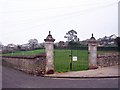
Park gates
This small park in Derrell Road is partly enclosed by an old wall with these unexpectedly ornate gate posts.
Image: © Richard Dorrell
Taken: 1 Jan 2009
0.04 miles
2
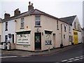
Corner shop
This shop stands on the corner of Hayes Road and Derrell Road, directly opposite the Devonport Arms public house.
Image: © Richard Dorrell
Taken: 1 Jan 2009
0.05 miles
3
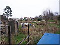
Derrell Road allotments
On the gate to the allotments, the name of the road is mis-spelt 'Derrel'.
Image: © Richard Dorrell
Taken: 1 Jan 2009
0.06 miles
4
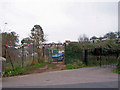
Contrasting entrance gates
The gate on the left is an entrance to the Derrell Road allotments.
The black and gold gates on the right are the entrance to the Kingdom Hall of Jehovah's Witnesses.
Image: © Richard Dorrell
Taken: 1 Jan 2009
0.06 miles
5
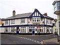
The Devonport Arms
A large public house on the corner Hayes Road and Elmbank Road.
Image: © Richard Dorrell
Taken: 1 Jan 2009
0.06 miles
6
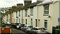
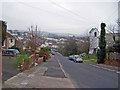
Elmbank Road, Paignton
Terraced houses line the street leading down from the Totnes Road.
Image: © Derek Harper
Taken: 13 Oct 2023
0.09 miles
7
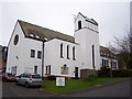
Tower House School, Paignton
The school is in Fisher Street. See its website http://www.towerhouseschool.co.uk/
Image: © Jennifer Vaughan
Taken: 7 Sep 2006
0.09 miles
8
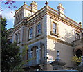
St Michael's Court
Renovated in 1985, this former church and flats behind it are now sheltered homes for the elderly managed by Guinness Care and Support Ltd.
Image: © Richard Dorrell
Taken: 1 Jan 2009
0.09 miles
9
Derrell Road
The 'tree' on the right is actually a telegraph pole, covered in ivy.
Behind it is St Michael's Court - a church converted into sheltered housing for the elderly.
Below that, the trees and shrubs are on the edge of Derrell Road allotments.
Image: © Richard Dorrell
Taken: 1 Jan 2009
0.10 miles
10
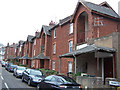
Flats in Merritt Road
Red stone built flats line both sides of Merritt Road, these ones having open staircases to the upper floor.
Image: © Richard Dorrell
Taken: 1 Jan 2009
0.11 miles