IMAGES TAKEN NEAR TO
Manaton Tor Road, PAIGNTON, TQ3 1AL
Introduction
This page details the photographs taken nearby to Manaton Tor Road, TQ3 1AL by members of the Geograph project.
The Geograph project started in 2005 with the aim of publishing, organising and preserving representative images for every square kilometre of Great Britain, Ireland and the Isle of Man.

There are currently over 7.5m images from over14,400 individuals and you can help contribute to the project by visiting https://www.geograph.org.uk
Image Map
Images are licensed for reuse under creativecommons.org/licenses/by-sa/2.0
Notes
- Clicking on the map will re-center to the selected point.
- The higher the marker number, the further away the image location is from the centre of the postcode.
Image Listing (99 Images Found)
Images are licensed for reuse under creativecommons.org/licenses/by-sa/2.0
Image
Details
Distance
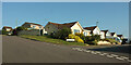
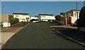
1
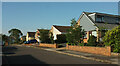
Manaton Tor Road
With a pleasing variety of colour on the gables of similar houses.
Image: © Derek Harper
Taken: 2 Jul 2021
0.02 miles
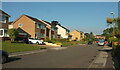
2
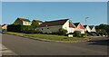
Junction, Longmead Road
The houses on Manaton Tor Road on the right are seen from the other direction in Image Those on the left are on Sharpitor Close.
Image: © Derek Harper
Taken: 2 Jul 2021
0.02 miles
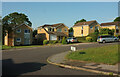
3
Junction, Green Park Road
With Manaton Tor Road (right).
Image: © Derek Harper
Taken: 2 Jul 2021
0.03 miles
4
Longmead Road
Houses on the south side of the road seen across the junction with Manaton Tor Road.
Image: © Derek Harper
Taken: 2 Jul 2021
0.04 miles
5
Green Park Road
The southern end of Green Park Road, seen across its junction with Longmead Road.
Image: © Derek Harper
Taken: 2 Jul 2021
0.04 miles
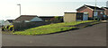
6
Grass area by Longmead Road
A plot remains for number 7 on the south side of the road, in a similar way to Image
Image: © Derek Harper
Taken: 2 Jul 2021
0.05 miles
7
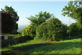
Windmill Lane
Trees have been removed from a short section of the south side of this old lane, offering a view across Tor Bay to Berry Head. The lane has been preserved as a path between housing estates and runs down the ridge between the Occombe and Shorton valleys above Paignton.
Image: © Derek Harper
Taken: 11 Apr 2008
0.07 miles
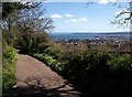
8

Windmill Lane
The old lane had two posts preventing vehicles from using it, although one seems to have gone. Seen from the junction shown in Image]; see also https://www.geograph.org.uk/search.php?i=161833552 .
Image: © Derek Harper
Taken: 2 Jul 2021
0.07 miles
9
Green Park Road
West of the junction with Manaton Tor Road.
Image: © Derek Harper
Taken: 2 Jul 2021
0.07 miles
10
Cranford Road, Paignton
Looking left from the junction seen in Image But the houses at the top of the hill ahead are on Kestor Drive.
Image: © Derek Harper
Taken: 2 Jul 2021
0.07 miles