IMAGES TAKEN NEAR TO
Padacre Road, TORQUAY, TQ2 8PU
Introduction
This page details the photographs taken nearby to Padacre Road, TQ2 8PU by members of the Geograph project.
The Geograph project started in 2005 with the aim of publishing, organising and preserving representative images for every square kilometre of Great Britain, Ireland and the Isle of Man.

There are currently over 7.5m images from over14,400 individuals and you can help contribute to the project by visiting https://www.geograph.org.uk
Image Map (Loading...)


Getting Data...Please wait
Leaflet Map data © OpenStreetMap
Images are licensed for reuse under creativecommons.org/licenses/by-sa/2.0
Notes
- Clicking on the map will re-center to the selected point.
- The higher the marker number, the further away the image location is from the centre of the postcode.
Image Listing (108 Images Found)
Images are licensed for reuse under creativecommons.org/licenses/by-sa/2.0
Image
Details
Distance
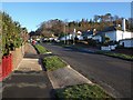
1
Padacre Road Nos 8 -18
Cul-de-sac off Padacre Road, Watcombe, Torquay; for the houses numbered 8 - 18
Image: © John C
Taken: 1 Dec 2015
0.02 miles
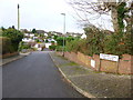
2
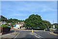
Padacre Road, Watcombe
The residential road climbs steeply up from the junction with Moor Lane; Brunel Woods are ahead on the right.
Image: © Derek Harper
Taken: 7 Feb 2009
0.03 miles
3
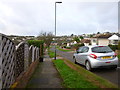
Bove Park Road
Bove Park Road at the top close to Padacre Road
Image: © John C
Taken: 1 Dec 2015
0.05 miles
4
Bove Park Road, Barton, Torquay
Bove Park Road looking westwards from Peasland Road end
Image: © John C
Taken: 1 Dec 2015
0.05 miles
5
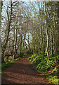
Path, The Avenues
A little further up the path shown in Image
Image: © Derek Harper
Taken: 11 Apr 2021
0.06 miles
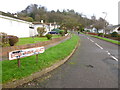
6
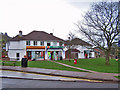
Watcombe shops and Post Office
This small parade of shops faces the junction of Moor Lane and Padacre Road. Don't post your letters in the wrong red box...
Image: © Richard Dorrell
Taken: 26 Mar 2010
0.07 miles
7
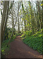
Path, The Avenues
On the southern slopes of Brunel Park.
Image: © Derek Harper
Taken: 11 Apr 2021
0.07 miles
8
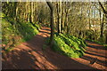
Path junction, Brunel Woods
The right fork drops beside the southern edge of the woods towards the Brunel Avenue exit. The left fork climbs in the direction of Brunel Manor towards the eastern of the Seymour Drive exits. https://historicengland.org.uk/listing/the-list/list-entry/1000141
Image: © Derek Harper
Taken: 11 Apr 2021
0.07 miles
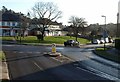
9
Junction of Moor Lane and Padacre Road, looking east
Image: © Rob Purvis
Taken: 27 Aug 2022
0.07 miles
10
Shops, Moor Lane, Watcombe
A small collection of shops set back from the junction of Moor Lane with Padacre Road (left), also seen in Image
Image: © Derek Harper
Taken: 7 Feb 2009
0.08 miles