IMAGES TAKEN NEAR TO
Edgeley Road, TORQUAY, TQ2 8ND
Introduction
This page details the photographs taken nearby to Edgeley Road, TQ2 8ND by members of the Geograph project.
The Geograph project started in 2005 with the aim of publishing, organising and preserving representative images for every square kilometre of Great Britain, Ireland and the Isle of Man.

There are currently over 7.5m images from over14,400 individuals and you can help contribute to the project by visiting https://www.geograph.org.uk
Image Map
Images are licensed for reuse under creativecommons.org/licenses/by-sa/2.0
Notes
- Clicking on the map will re-center to the selected point.
- The higher the marker number, the further away the image location is from the centre of the postcode.
Image Listing (151 Images Found)
Images are licensed for reuse under creativecommons.org/licenses/by-sa/2.0
Image
Details
Distance
1
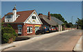
Edgeley Road, Barton
A short cul-de-sac off Isaacs Road.
Image: © Derek Harper
Taken: 27 Jun 2018
0.02 miles
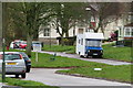
2
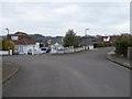
Isaacs Road, Barton
A residential street in this area on the edge of Torbay
Image: © David Smith
Taken: 27 Feb 2016
0.02 miles
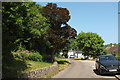
3
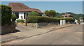
Isaacs Road, Barton
The road describes a sort of crescent off Barton Hill Road, though this southern arm meets Clennon Lane shortly before it can reach the main road.
Image: © Derek Harper
Taken: 27 Jun 2018
0.04 miles
4

Houses on Fore Street, Barton
Seen on the left of Image
Image: © Derek Harper
Taken: 10 Jan 2020
0.05 miles
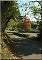
5
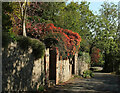
Clennon Lane
Some autumn colour on the eastbound one-way section of the road, courtesy of Virginia creeper and an acer.
Image: © Derek Harper
Taken: 14 Oct 2020
0.05 miles
6
Acer, Clennon Lane
On the strip of land between the two one-way arms of the lane, which join immediately beyond it.
Image: © Derek Harper
Taken: 14 Oct 2020
0.05 miles
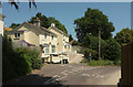
7
Two lanes of Clennon Lane
One section of Clennon Lane divides into two carriageways, one in each direction.
Image: © John C
Taken: 29 Mar 2018
0.06 miles
8
Clennon Lane
The westbound half of the lane (see Image]) meets the eastbound section about 25 metres ahead of the camera. The cottages right of centre are on Fore Street.
Image: © Derek Harper
Taken: 27 Jun 2018
0.06 miles
9
Clennon Lane
Clennon Lane becomes a dual carriageway at this point for 150 metres, with a steep-sided wooded central reservation about 10 metres wide, as it drops between Barton and Watcombe.
Image: © Derek Harper
Taken: 27 Jun 2018
0.06 miles
10
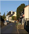
Fore Street, Barton
The two houses further up the hill are both listed; the nearer is described as "House and shop. c1850, possibly with earlier core" - see http://www.imagesofengland.org.uk/Details/Default.aspx?id=390605&mode=adv . The thatched cottage beside it is "Probably C18. Plastered cob; thatched roof with plain ridge, hipped at ends ... Formerly part of a court of cottages". See http://www.imagesofengland.org.uk/Details/Default.aspx?id=390606&mode=adv .
Image: © Derek Harper
Taken: 7 Feb 2009
0.06 miles