IMAGES TAKEN NEAR TO
Glebeland Way, TORQUAY, TQ2 7SL
Introduction
This page details the photographs taken nearby to Glebeland Way, TQ2 7SL by members of the Geograph project.
The Geograph project started in 2005 with the aim of publishing, organising and preserving representative images for every square kilometre of Great Britain, Ireland and the Isle of Man.

There are currently over 7.5m images from over14,400 individuals and you can help contribute to the project by visiting https://www.geograph.org.uk
Image Map (Loading...)


Getting Data...Please wait
Leaflet Map data © OpenStreetMap
Images are licensed for reuse under creativecommons.org/licenses/by-sa/2.0
Notes
- Clicking on the map will re-center to the selected point.
- The higher the marker number, the further away the image location is from the centre of the postcode.
Image Listing (101 Images Found)
Images are licensed for reuse under creativecommons.org/licenses/by-sa/2.0
Image
Details
Distance
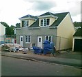
1
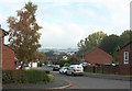
Path to Glebeland Way, Shiphay
Near the head of quite a lengthy cul-de-sac, at the foot of Image
Image: © Derek Harper
Taken: 23 Oct 2019
0.02 miles
2
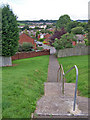
Footpath to Glebeland Way
This footpath, with steps because of the steepness of the hillside, leads from Exe Hill to the southern end of Glebeland Way. Glebeland Way is a cul-de-sac.
Image: © Richard Dorrell
Taken: 27 Aug 2010
0.03 miles
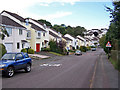
3
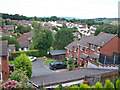
Glebeland Way from Exe Hill
The houses in the foreground are at the southern end of Glebeland Way - a cul-de-sac which has its entrance in Fowey Avenue. This view is taken from Exe Hill.
Image: © Richard Dorrell
Taken: 27 Aug 2010
0.03 miles
4
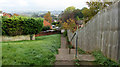
Path to Glebeland Way, Shiphay
Dropping from Exe Hill.
Image: © Derek Harper
Taken: 23 Oct 2019
0.05 miles
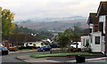
5
Exe Hill, Shiphay
Smart private housing on the eastern edge of the built up part of Torbay. The road has 'traffic calming' speed humps every hundred metres or so.
This grid square contains approximately half housing estate, and half countryside.
Image: © Richard Dorrell
Taken: 27 Aug 2010
0.05 miles
6
Culm Close, Shiphay
From Exe Hill. A muffler of mist adorns a hillside above Kingskerswell.
Image: © Derek Harper
Taken: 23 Oct 2019
0.05 miles
7
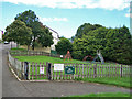
Exehill play area
A small play area at the side of Exe Hill. It is rather poorly equipped, and has the look of being little used.
Image: © Richard Dorrell
Taken: 27 Aug 2010
0.08 miles
8
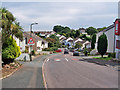
Exe Hill
A smart housing development on the western edge of Torbay. The road has 'traffic calming' speed humps every hundred metres or so throughout its length.
Image: © Richard Dorrell
Taken: 27 Aug 2010
0.08 miles
10
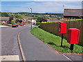
Post box in Fowey Avenue
Fowey Avenue is a loop of road from Exe Hill, on the western edge of the Torbay conurbation. To the left is miles of open countryside. To the right is Torbay.
Image: © Richard Dorrell
Taken: 27 Aug 2010
0.10 miles