IMAGES TAKEN NEAR TO
Powderham Road, TORQUAY, TQ2 7QU
Introduction
This page details the photographs taken nearby to Powderham Road, TQ2 7QU by members of the Geograph project.
The Geograph project started in 2005 with the aim of publishing, organising and preserving representative images for every square kilometre of Great Britain, Ireland and the Isle of Man.

There are currently over 7.5m images from over14,400 individuals and you can help contribute to the project by visiting https://www.geograph.org.uk
Image Map
Images are licensed for reuse under creativecommons.org/licenses/by-sa/2.0
Notes
- Clicking on the map will re-center to the selected point.
- The higher the marker number, the further away the image location is from the centre of the postcode.
Image Listing (408 Images Found)
Images are licensed for reuse under creativecommons.org/licenses/by-sa/2.0
Image
Details
Distance

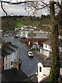
2
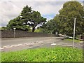
Junction on Barton Road
Powderham Road (right) meets Barton road at this T-junction; across the road is the wall of Torquay Cemetery.
Image: © Derek Harper
Taken: 14 Jul 2012
0.02 miles
3
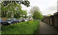
Luxuriant verge, Barton Road
Spring bursting forth by the suburban road at Hele, doubtless due for a trimming soon. I doubt that any unusual specimens will suffer.
Image: © Derek Harper
Taken: 18 May 2018
0.03 miles
4
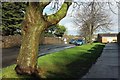
Barton Road, Torquay
At the crest of a rise between the housing estate of Pendennis Raoad on the right and the old cemetery on the left.
Image: © Derek Harper
Taken: 3 Jan 2016
0.03 miles
5
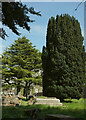
Conifers, Torquay Old Cemetery
A cedar and a yew in the northeast part of the cemetery.
Image: © Derek Harper
Taken: 3 May 2022
0.03 miles
6
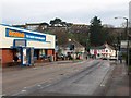
Hele Road, Torquay
The road, the B3199, leads away from the roundabout at the crossroads with Barton Hill Road, changing character as it rounds the bend to wind between terraces down a valley. The shop on the left was formerly a conventional supermarket, which contained a post office.
Roads on the estate on the hill in the background are named after cathedral towns.
Image: © Derek Harper
Taken: 30 Nov 2008
0.03 miles
7
Hele Road, Torquay
The B3199 between the junction with Salisbury Avenue (below) and the roundabout at Barton Road. Beyond the Farm Foods supermarket and the BP station is the newer part of Torquay cemetery.
Image: © Derek Harper
Taken: 26 Nov 2012
0.03 miles
8
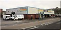
Farm Foods, Hele
The frozen food specialist supermarket is currently closed for refurbishment. Hele Road is the B3199.
Image: © Derek Harper
Taken: 25 Jan 2014
0.03 miles
9
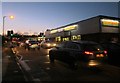
Farm Foods, Torquay
The frozen food store at twilight, with rush hour traffic on the B3199 Hele Road.
Image: © Derek Harper
Taken: 16 Jan 2015
0.03 miles
10
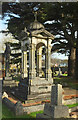
Memorial, Torquay Old Cemetery
A "white marble baldachino commemorating Lizzie Davies (d 1907)" https://historicengland.org.uk/listing/the-list/list-entry/1001578?section=official-listing , in the northeast part of the listed cemetery.
Image: © Derek Harper
Taken: 6 Feb 2022
0.04 miles