IMAGES TAKEN NEAR TO
Berkeley Avenue, TORQUAY, TQ2 7LE
Introduction
This page details the photographs taken nearby to Berkeley Avenue, TQ2 7LE by members of the Geograph project.
The Geograph project started in 2005 with the aim of publishing, organising and preserving representative images for every square kilometre of Great Britain, Ireland and the Isle of Man.

There are currently over 7.5m images from over14,400 individuals and you can help contribute to the project by visiting https://www.geograph.org.uk
Image Map
Images are licensed for reuse under creativecommons.org/licenses/by-sa/2.0
Notes
- Clicking on the map will re-center to the selected point.
- The higher the marker number, the further away the image location is from the centre of the postcode.
Image Listing (221 Images Found)
Images are licensed for reuse under creativecommons.org/licenses/by-sa/2.0
Image
Details
Distance
1
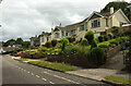
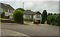
Berkeley Avenue, Shiphay
Houses on the south side of the cul-de-sac, facing the parking area shown in Image
Image: © Derek Harper
Taken: 3 Jul 2021
0.00 miles
2
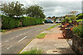
Berkeley Avenue, Shiphay
A cul-de-sac on the Cadewell estate. Edginswell Close is nearby on the left, which explains the absence of houses on that side of the road west of the roadside parking area. No way through to it, though.
Image: © Derek Harper
Taken: 3 Jul 2021
0.02 miles
3
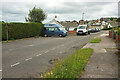
Berkeley Avenue, Shiphay
As mentioned at Image], this cul-de-sac runs near Edginswell Close on the north (left) side. This roadside parking area manages to be fitted in, before houses commence beyond.
Image: © Derek Harper
Taken: 3 Jul 2021
0.02 miles
4

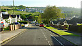
Junction, Berkeley Avenue, Shiphay
Berkeley Rise climbs steeply to the right.
Image: © Derek Harper
Taken: 3 Jul 2021
0.02 miles
5
Berkeley Rise, Shiphay
From its junction with Higher Cadewell Lane. Across the valley is the new estate on Primrose Hill Image
Image: © Derek Harper
Taken: 5 Jun 2021
0.05 miles
6
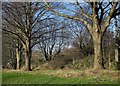
Trees by the Newton Road
These are at the top of a bank north of the former main road out of Torquay. Behind the fence is a cutting containing the railway line. Image was taken a little further east.
Image: © Derek Harper
Taken: 9 Jan 2015
0.05 miles
7
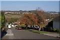
Berkeley Rise, Torquay
A colourful tree on the steep hill in this road of bungalows in Shiphay, seen from Higher Cadewell Lane. In the background is Scott's Meadow - see Image, with part of Barton New Town behind it.
Image: © Derek Harper
Taken: 2 Nov 2007
0.05 miles
8
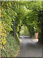
Collaton Road
An old lane pressed into service as a one-way street as it climbs towards Higher Cadewell Lane.
Image: © Derek Harper
Taken: 30 Sep 2010
0.05 miles
9
Berkeley Avenue, Shiphay
The end of the cul-de-sac.
Image: © Derek Harper
Taken: 3 Jul 2021
0.06 miles
10

Berkeley Avenue, Shiphay
From the junction shown in Image], showing the stretch of the road heading up to the T junction with Grosvenor Close.
Image: © Derek Harper
Taken: 3 Jul 2021
0.06 miles