IMAGES TAKEN NEAR TO
Higher Cadewell Lane, TORQUAY, TQ2 7EU
Introduction
This page details the photographs taken nearby to Higher Cadewell Lane, TQ2 7EU by members of the Geograph project.
The Geograph project started in 2005 with the aim of publishing, organising and preserving representative images for every square kilometre of Great Britain, Ireland and the Isle of Man.

There are currently over 7.5m images from over14,400 individuals and you can help contribute to the project by visiting https://www.geograph.org.uk
Image Map
Images are licensed for reuse under creativecommons.org/licenses/by-sa/2.0
Notes
- Clicking on the map will re-center to the selected point.
- The higher the marker number, the further away the image location is from the centre of the postcode.
Image Listing (173 Images Found)
Images are licensed for reuse under creativecommons.org/licenses/by-sa/2.0
Image
Details
Distance
1
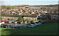
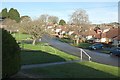
Housing at Shiphay and beyond
In the foreground, a steep recreational fields drops to houses facing onto Higher Cadewell Lane, with the Cadewell estate beyond. In the distance, alongside the extensive Barton New Town (centre and right), is a new construction site called Primrose Hill, built on the distinctive red soil of much of Devon. At top right is Orestone Plantation.
Image: © Derek Harper
Taken: 28 Feb 2017
0.01 miles
2
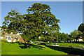
Tree by Higher Cadewell Lane
A sycamore, I think, with Crosspark Avenue running down to meet Higher Cadewell Lane on the right.
Image: © Derek Harper
Taken: 5 Jun 2021
0.02 miles
3
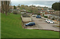
Car park, Cadewell
Tucked away behind houses on Higher cadewell Lane and Crosspark Avenue.
Image: © Derek Harper
Taken: 10 Mar 2023
0.02 miles
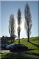
4
Housing at Shiphay
A view between two of the poplars shown in Image] of houses on Crosspark Avenue and Higher Cadewell Lane, plus the green space, curving path and trees on the other side of the junction.
Image: © Derek Harper
Taken: 28 Feb 2017
0.02 miles
5
Higher Cadewell Lane
The junction with Crosspark Avenue seen from the entrance to the car park shown in Image
Image: © Derek Harper
Taken: 28 Feb 2017
0.03 miles
6
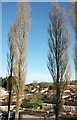
Poplars, Shiphay
Image: © Derek Harper
Taken: 28 Feb 2017
0.03 miles
7
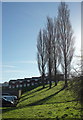
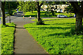
Green space, Shiphay
A steep recreational field with a group of poplars, also seen in Image] and Image], and seen here from Maple Walk. I think the steep terrace behind must belong to Wallace Avenue.
Image: © Derek Harper
Taken: 28 Feb 2017
0.03 miles
8
Poplars, Shiphay
Another view of the poplars shown in Image
Image: © Derek Harper
Taken: 28 Feb 2017
0.04 miles
9
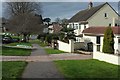
Path, Shiphay
A lovely early summer morning. The path is heading for the junction of Crosspark Avenue with Higher Cadewell Lane (left).
Image: © Derek Harper
Taken: 5 Jun 2021
0.04 miles
10
Higher Cadewell Lane, Shiphay
From its junction with Cadewell Lane. The road dips to the junction with Image] and then climbs again.
Image: © Derek Harper
Taken: 3 Mar 2016
0.04 miles