IMAGES TAKEN NEAR TO
Wheatridge Lane, TORQUAY, TQ2 6QZ
Introduction
This page details the photographs taken nearby to Wheatridge Lane, TQ2 6QZ by members of the Geograph project.
The Geograph project started in 2005 with the aim of publishing, organising and preserving representative images for every square kilometre of Great Britain, Ireland and the Isle of Man.

There are currently over 7.5m images from over14,400 individuals and you can help contribute to the project by visiting https://www.geograph.org.uk
Image Map (Loading...)


Getting Data...Please wait
Leaflet Map data © OpenStreetMap
Images are licensed for reuse under creativecommons.org/licenses/by-sa/2.0
Notes
- Clicking on the map will re-center to the selected point.
- The higher the marker number, the further away the image location is from the centre of the postcode.
Image Listing (326 Images Found)
Images are licensed for reuse under creativecommons.org/licenses/by-sa/2.0
Image
Details
Distance
1
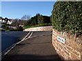
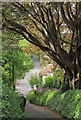
Junction on Livermead Hill
To the right is Old Mill Road, beginning a long journey across two valleys through to Chelston. Ahead is Wheatridge Lane, passing through the housing of Livermead.
Image: © Derek Harper
Taken: 20 Dec 2009
0.03 miles
2
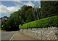
Hedge on wall, Wheatridge Lane
Of course, it's rooted behind the wall, but it's always an interesting effect. The road drops to the junction with Broadpark Road (right).
Image: © Derek Harper
Taken: 4 Jun 2021
0.04 miles
3
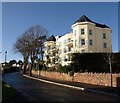
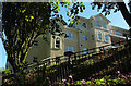
Flats on Livermead Hill
Sunleigh is a converted hotel of 9 apartments at the junction with Old Mill Road.
Image: © Derek Harper
Taken: 20 Dec 2009
0.04 miles
4
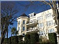
Flats on Livermead Hill
A closer view of Image The hotel from which it was converted had 20 bedrooms.
Image: © Derek Harper
Taken: 20 Dec 2009
0.04 miles
5
Old Mill Road, Livermead
A section of the road that resembles a country lane. Because of its narrowness, it is one-way, in the direction of view. Image] can be spotted still, by the gate pier.
Image: © Derek Harper
Taken: 23 May 2020
0.04 miles
6
Flats, Livermead
Hyperion is a block of 24 flats, seen here from Underhill Road.
Image: © Derek Harper
Taken: 27 Aug 2020
0.05 miles
7
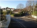
Broadpark Road, Livermead
In the foreground is Wheatridge Lane. The tree-lined Broadpark Road on the right climbs fairly steeply up through Livermead, through a history of twentieth-century housing to a modern estate at the top of the hill.
Image: © Derek Harper
Taken: 20 Dec 2009
0.05 miles
8
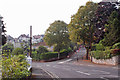
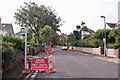
Road junction, Livermead
The photographer is in Livermead Hill, looking towards the junction with Broadpark Road. Gas main repairs are taking place in Broadpark Road - see Image
Image: © Richard Dorrell
Taken: 18 Sep 2014
0.05 miles
9
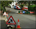
Roadworks, Livermead
Oh dear! Surely roadworks at a junction like this, often taken by motorists at some speed, merit traffic lights? Notice also how pedestrians are thrust into what's left of the road, without a protective barrier. Well, well, no wonder, it looks as though Virgin Media are involved, as that is a Volt2 van on Wheatridge Lane; see Image and Image Watch out, trees, as well as pedestrians and motorists.
Image: © Derek Harper
Taken: 19 Sep 2023
0.05 miles
10
Roadworks in Broadpark Road, Livermead
The works are connected with gas main repair.
Image: © Richard Dorrell
Taken: 18 Sep 2014
0.05 miles