IMAGES TAKEN NEAR TO
Drake Avenue, TORQUAY, TQ2 6JL
Introduction
This page details the photographs taken nearby to Drake Avenue, TQ2 6JL by members of the Geograph project.
The Geograph project started in 2005 with the aim of publishing, organising and preserving representative images for every square kilometre of Great Britain, Ireland and the Isle of Man.

There are currently over 7.5m images from over14,400 individuals and you can help contribute to the project by visiting https://www.geograph.org.uk
Image Map
Images are licensed for reuse under creativecommons.org/licenses/by-sa/2.0
Notes
- Clicking on the map will re-center to the selected point.
- The higher the marker number, the further away the image location is from the centre of the postcode.
Image Listing (124 Images Found)
Images are licensed for reuse under creativecommons.org/licenses/by-sa/2.0
Image
Details
Distance
1
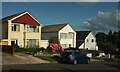
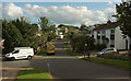
Houses on Drake Avenue, Shiphay
Three detached houses on a hill above the junction with Frobisher Green.
Image: © Derek Harper
Taken: 28 Jul 2021
0.03 miles
2
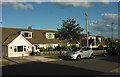
Houses on Drake Avenue, Shiphay
Semis at the northern summit of the road.
Image: © Derek Harper
Taken: 28 Jul 2021
0.03 miles
3
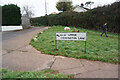
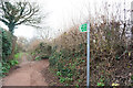
Turf zone "AmandaBush"
Path leading to Nut Bush Lane, Torquay
Image: © Ian S
Taken: 11 Feb 2023
0.03 miles
4
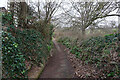
Upper Cockington Lane
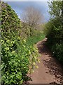
Once one of the few roads in the vicinity, this part of the lane is now reduced to a footpath (TQ 180) running between Drake Avenue and Armada Park recreation ground. https://www.heritagegateway.org.uk/Gateway/Results_Single.aspx?uid=MDV123632&resourceID=104 describes its former significance as a route. Here Alexanders reaches out across the tarmac.
Image: © Derek Harper
Taken: 12 May 2010
0.04 miles
5
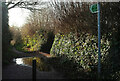
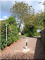
Upper Cockington Lane
What was a suburban road in Image] is here a public footpath, TQ 180.
Image: © Derek Harper
Taken: 16 Jan 2021
0.05 miles
7
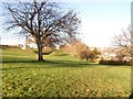
Armada Park
A sports field and dog-walking area.
Image: © Paul Hutchinson
Taken: 25 Nov 2008
0.05 miles
8
Drake Avenue, Shiphay
At the junction with Frobisher Green (left).
Image: © Derek Harper
Taken: 28 Jul 2021
0.05 miles
9
Upper Cockington Lane
This is where the path shown in Image regains some status as a motorable road, albeit as a cul-de-sac to some properties.
Image: © Derek Harper
Taken: 12 May 2010
0.06 miles