IMAGES TAKEN NEAR TO
Gilbert Avenue, TEIGNMOUTH, TQ14 9NN
Introduction
This page details the photographs taken nearby to Gilbert Avenue, TQ14 9NN by members of the Geograph project.
The Geograph project started in 2005 with the aim of publishing, organising and preserving representative images for every square kilometre of Great Britain, Ireland and the Isle of Man.

There are currently over 7.5m images from over14,400 individuals and you can help contribute to the project by visiting https://www.geograph.org.uk
Image Map
Images are licensed for reuse under creativecommons.org/licenses/by-sa/2.0
Notes
- Clicking on the map will re-center to the selected point.
- The higher the marker number, the further away the image location is from the centre of the postcode.
Image Listing (42 Images Found)
Images are licensed for reuse under creativecommons.org/licenses/by-sa/2.0
Image
Details
Distance
1
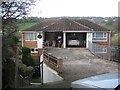
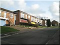
Semi-detached house on a steep slope, Bligh Close, Teignmouth
Apparently, a bridge allows vehicle access to first floor garages. How the rest of the house is arranged is not known but it could be that reception rooms and kitchen are on the first floor with bedrooms and bathroom downstairs. At lower left the footpath through the northwest side of the estate drops steeply down to Gilbert Avenue.
Image: © Robin Stott
Taken: 11 Dec 2012
0.03 miles
2
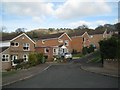
North end of Bligh Close, Teignmouth
Here conventional detached houses march up the hill on the edge of countryside.
Image: © Robin Stott
Taken: 11 Dec 2012
0.05 miles
3
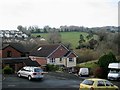
West across the end of Gilbert Avenue, Teignmouth
Across the valley of the Buddle Brook the Moor View Drive estate stops abruptly against farmland, but for how long?
Image: © Robin Stott
Taken: 11 Dec 2012
0.05 miles
4
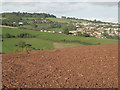
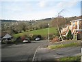
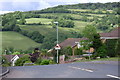
Houses climb the hills above Teignmouth
The view is northeast from near the summit of The Lea. Shepherds' Lane descends from the left towards Headway Cross. Coombe Way/Lane is out of sight below the field in the foreground. Woodland on the left skyline is Holcombe Down. Much of the housing on the right is on the eastern slope of the Coombe valley. New housing developments continue to advance up the hillsides.
Image: © Robin Stott
Taken: 29 Sep 2010
0.07 miles
5
Houses with external stairs, Admirals Walk, Teignmouth
Houses of a similar type are also seen in http://www.geograph.org.uk/photo/3825144 and http://www.geograph.org.uk/photo/3825236
Image: © Robin Stott
Taken: 11 Dec 2012
0.08 miles
6
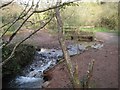
Ford and footbridge on Buddle Brook, Coombe Valley Local Nature Park, Teignmouth
There had been heavy rain in previous days. The brook in spate has coursed through this old ford and stripped the ground of vegetation and soil. Branches of coppiced hazel, a feature of the park, get into the picture.
Image: © Robin Stott
Taken: 11 Dec 2012
0.10 miles
7
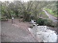
A full Buddle Brook, Coombe Valley Local Nature Park, Teignmouth
There had been heavy rain in previous days. The brook in spate has coursed through this old ford and stripped the ground of vegetation and soil. Note the coppiced hazel, a feature of the park.
Image: © Robin Stott
Taken: 11 Dec 2012
0.10 miles
8
Northwest end of Armada Drive, Teignmouth
Seen from the footpath that runs mostly between garden fences on the northwest edge of this estate off Raleigh Road. Will this idyllic landscape one day be covered in houses all the way up to Holcombe Down, right, and Little Haldon? Houses similar to those on the right are also seen in http://www.geograph.org.uk/photo/3825144 and http://www.geograph.org.uk/photo/3825242
Image: © Robin Stott
Taken: 11 Dec 2012
0.12 miles
9
Low gear now - Raleigh Road, Teignmouth
How long before those fields are covered in sprawl too?
Image: © Robin Stott
Taken: 7 Jun 2009
0.15 miles
10
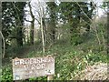
Entrance to Frobisher Wood, Frobisher Close, Teignmouth
A piece of lush green Devonshire woodland and a public open space. The sign also says Teignbridge District Council / Supported by the Countryside Commission.
The Countryside Commission as such was set up in 1968. It ceased to exist in 1999 when it was merged with the Rural Development Commission to form the Countryside Agency. This has in turn evolved into Natural England, partly by eventual merger with English Nature. http://en.wikipedia.org/wiki/Countryside_Commission
Image: © Robin Stott
Taken: 11 Dec 2012
0.16 miles