IMAGES TAKEN NEAR TO
Hermosa Road, TEIGNMOUTH, TQ14 9LA
Introduction
This page details the photographs taken nearby to Hermosa Road, TQ14 9LA by members of the Geograph project.
The Geograph project started in 2005 with the aim of publishing, organising and preserving representative images for every square kilometre of Great Britain, Ireland and the Isle of Man.

There are currently over 7.5m images from over14,400 individuals and you can help contribute to the project by visiting https://www.geograph.org.uk
Image Map
Images are licensed for reuse under creativecommons.org/licenses/by-sa/2.0
Notes
- Clicking on the map will re-center to the selected point.
- The higher the marker number, the further away the image location is from the centre of the postcode.
Image Listing (509 Images Found)
Images are licensed for reuse under creativecommons.org/licenses/by-sa/2.0
Image
Details
Distance
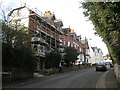
3
Part of Nos. 3-31, Coombe Vale Road, Teignmouth
Image: © Robin Stott
Taken: 11 Dec 2012
0.04 miles
4
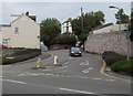
Southern end of Coombe Vale Road, Teignmouth
Viewed across the A379 Bitton Park Road.
Image: © Jaggery
Taken: 21 Apr 2016
0.04 miles
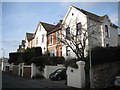
5
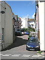
Chelsea Place, off Bitton Park Road, Teignmouth
Image: © Robin Stott
Taken: 19 Aug 2012
0.05 miles
6
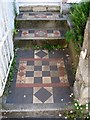
Tiled front path and steps, no.1 Chelsea Place, Teignmouth
Image: © Robin Stott
Taken: 6 Jul 2013
0.05 miles
7
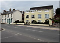
Bitton Park Road houses, Teignmouth
Houses on the north side of the A379 Bitton Park Road viewed from the corner of Park Hill.
Image: © Jaggery
Taken: 21 Apr 2016
0.05 miles
8
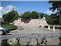
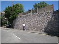
Retaining wall, Coombe Vale Road
The A379 through Teignmouth and its continuation the A381 are characterised by a whole series of retaining walls, the mark of past road-widening. The view is across Bitton Park Road at its junction with Coombe Vale Road.
Image: © Robin Stott
Taken: 19 Aug 2012
0.06 miles
9
Retaining wall, southeast end of Coombe Vale Road, Teignmouth
The remodelling of the southeast end of Coombe Vale Road (originally Coombe Road) and the widening of Bitton Park Road (originally Bitton Road) appears on a map of 1963, along with the award-winning Regency-flavoured flats and maisonettes on Parson Street and Gloucester Road that replaced bomb-damaged crowded terraces. See http://www.geograph.org.uk/photo/3387960 and http://www.geograph.org.uk/photo/4056645
Image: © Robin Stott
Taken: 6 Jul 2013
0.06 miles
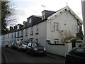
10
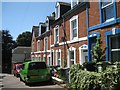
West side of Chelsea Place, Teignmouth
Chelsea Place is a pleasing cul-de-sac to the north of Bitton Park Road. Two terraces of nine houses each face each other across the narrow street. A few have ornamental tiled front paths and steps which have survived. http://www.geograph.org.uk/photo/4056590 http://www.geograph.org.uk/photo/4056595 http://www.geograph.org.uk/photo/4056602 http://www.geograph.org.uk/photo/4056606
Image: © Robin Stott
Taken: 6 Jul 2013
0.06 miles