IMAGES TAKEN NEAR TO
Gloucester Road, TEIGNMOUTH, TQ14 9HN
Introduction
This page details the photographs taken nearby to Gloucester Road, TQ14 9HN by members of the Geograph project.
The Geograph project started in 2005 with the aim of publishing, organising and preserving representative images for every square kilometre of Great Britain, Ireland and the Isle of Man.

There are currently over 7.5m images from over14,400 individuals and you can help contribute to the project by visiting https://www.geograph.org.uk
Image Map (Loading...)


Getting Data...Please wait
Leaflet Map data © OpenStreetMap
Images are licensed for reuse under creativecommons.org/licenses/by-sa/2.0
Notes
- Clicking on the map will re-center to the selected point.
- The higher the marker number, the further away the image location is from the centre of the postcode.
Image Listing (681 Images Found)
Images are licensed for reuse under creativecommons.org/licenses/by-sa/2.0
Image
Details
Distance
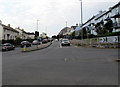
1
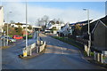
Gloucester Road houses, Teignmouth
Viewed from the corner of Exeter Road. Gloucester Road leads to Hermosa Gardens and Minden Road.
Image: © Jaggery
Taken: 21 Apr 2016
0.02 miles
2
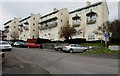
Regency-flavour local authority flats, Gloucester Road, Teignmouth
These flats, and the accompanying road realignments, were completed between 1963 and 1977, according to old OS maps. The balconies echo features of the many Regency villas in the town. The view is across the southern end of Exeter Road, which was realigned away from narrow Exeter Street in this period. Bitton Street and other roads were widened to become the present A379 through Teignmouth. It was a radical change to the town's fabric that appears to have been planned in the post-war years: the site of these flats, and their neighbours on Bitton Park Road, was shown cleared on a map of 1955, with similar flats in place on the south side of the road. The reason was perhaps three-fold: to improve the housing stock, to improve lorry access to the port, and to remove coastal holiday traffic from the narrow streets of the town centre.
Image: © Robin Stott
Taken: 15 Mar 2016
0.02 miles
3
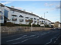
Refurbished flats, on Bitton Park Road, Teignmouth
Image: © Roger Cornfoot
Taken: 12 Nov 2008
0.04 miles
4
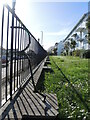
Fence of Bitton Park flats
The fence is a sturdy metal one, with distinctive supprts. You might have supposed the buildings' name begins with an 'R'.
Image: © Neil Owen
Taken: 30 Mar 2024
0.04 miles
5
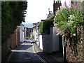
Exeter Street, Teignmouth
Looking south-south-east to St James's church.
Image: © Robin Stott
Taken: 7 Jun 2009
0.04 miles
6
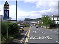
Invitation to escape, Exeter Road, Teignmouth
The approach to Teignmouth from the north is unnerving for the first-time visitor - a long, ever-steepening descent, culminating in this thoughtful provision.
Image: © Robin Stott
Taken: 7 Jun 2009
0.04 miles
7
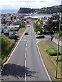
The final descent, Exeter Road, Teignmouth
From the footbridge
Image: © Robin Stott
Taken: 7 Jun 2009
0.04 miles
8
West along Bitton Park Road, Teignmouth
This is the eastern end of the A379 Bitton Park Road. The A379 Exeter Road is on the camera side.
Turn right into the B3192 Exeter Road for Haldon (3 miles) and Exeter.
Image: © Jaggery
Taken: 21 Apr 2016
0.04 miles
9
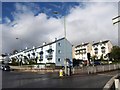
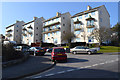
Flats in Teignmouth
The address of the buildings is Gloucester Road, the side road visible in the background on the right. With the distinctive canopies on their balconies, they dominate the section of Bitton Park Road (the A379, left) immediately west of the traffic lights at this junction, where Exeter Road (the B3192) climbs steeply to the right.
Image: © Derek Harper
Taken: 23 Oct 2010
0.04 miles