IMAGES TAKEN NEAR TO
Coombe Vale Road, TEIGNMOUTH, TQ14 9EW
Introduction
This page details the photographs taken nearby to Coombe Vale Road, TQ14 9EW by members of the Geograph project.
The Geograph project started in 2005 with the aim of publishing, organising and preserving representative images for every square kilometre of Great Britain, Ireland and the Isle of Man.

There are currently over 7.5m images from over14,400 individuals and you can help contribute to the project by visiting https://www.geograph.org.uk
Image Map (Loading...)


Getting Data...Please wait
Leaflet Map data © OpenStreetMap
Images are licensed for reuse under creativecommons.org/licenses/by-sa/2.0
Notes
- Clicking on the map will re-center to the selected point.
- The higher the marker number, the further away the image location is from the centre of the postcode.
Image Listing (188 Images Found)
Images are licensed for reuse under creativecommons.org/licenses/by-sa/2.0
Image
Details
Distance
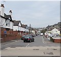
2
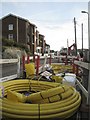
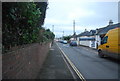
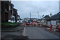
Replacement of the gas supply in prospect, Coombe Vale Road, Teignmouth
Streetworks were still happening in January 2013 http://www.geograph.org.uk/photo/3471341
Image: © Robin Stott
Taken: 11 Dec 2012
0.03 miles
5
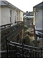
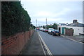
Upside-down houses, Coombe Vale Road, Teignmouth
These semi-detached houses are built on a steep slope. The one on the left has its front door at first floor level, reached by a deck. Goodness knows how the rest of the house is arranged.
Image: © Robin Stott
Taken: 11 Dec 2012
0.07 miles
6
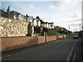
Bungalows above retaining walls, Coombe Vale Road, Teignmouth
Image: © Robin Stott
Taken: 11 Dec 2012
0.07 miles
7
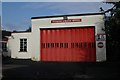
Teignmouth fire station
Teignmouth fire station, First Avenue, Teignmouth, Devon. Replaced in January 2006 by a new fire station on Exeter Road, Teignmouth.
Image: © Kevin Hale
Taken: 13 Nov 2005
0.07 miles
9
First Avenue, Teignmouth
Extending northwards for 200 metres from the A379 Bitton Park Road.
First Avenue is a dead end road, ending at the edge of Bitton Brook.
Image: © Jaggery
Taken: 21 Apr 2016
0.08 miles
10
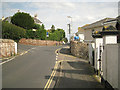
Junction on Coombe Vale Road
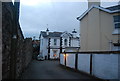
One of West Teignmouth's older residential roads, with early 19th-century villas sporting characteristically shallow-pitched roofs (right). Landscore Road comes in from the left; Keatings Lane drops steeply down right; the top of Reed Vale is hardly visible beyond the lighting column. Another view of the junction is Image
Image: © Robin Stott
Taken: 14 Jul 2012
0.08 miles