IMAGES TAKEN NEAR TO
Strand, TEIGNMOUTH, TQ14 8XZ
Introduction
This page details the photographs taken nearby to Strand, TQ14 8XZ by members of the Geograph project.
The Geograph project started in 2005 with the aim of publishing, organising and preserving representative images for every square kilometre of Great Britain, Ireland and the Isle of Man.

There are currently over 7.5m images from over14,400 individuals and you can help contribute to the project by visiting https://www.geograph.org.uk
Image Map
Images are licensed for reuse under creativecommons.org/licenses/by-sa/2.0
Notes
- Clicking on the map will re-center to the selected point.
- The higher the marker number, the further away the image location is from the centre of the postcode.
Image Listing (1239 Images Found)
Images are licensed for reuse under creativecommons.org/licenses/by-sa/2.0
Image
Details
Distance
1

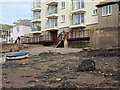
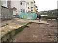
Saturday afternoon visitors to Teignmouth's back beach
Behind the group are walls and a jetty projecting into the river, all that remains of the Morgan Giles boat-building yard. The flats, left, were built on the site around 1990.
Image: © Robin Stott
Taken: 14 Jul 2012
0.01 miles
2
Walkway along river frontage of Morgans Quay flats, Strand, Teignmouth
When the flats were built around 1990 a public right of way was established to allow access to moorings on the back beach and to form a continuous walk along the river waterfront.
Image: © Robin Stott
Taken: 30 Apr 2014
0.01 miles
3
The south end of New Quay, Teignmouth
Flats looking over the Teign estuary
Image: © David Smith
Taken: 21 Jun 2019
0.01 miles
4
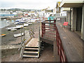
No access off the boardwalk
The boardwalk along the river frontage of the Morgans Quay flats is a public right of way. It has been closed temporarily while a flood wall is being constructed at No.9 Forester's Terrace.
Image: © Robin Stott
Taken: 5 May 2012
0.01 miles
5
Flood wall under construction
A deep concrete wall has been constructed against No.9 Forester's Terrace to prevent tidal flooding of the property. Here it is being clad with local Devonian limestone to match other walls nearby.
Image: © Robin Stott
Taken: 5 May 2012
0.01 miles
6
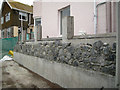
Completed flood wall to a Foresters Terrace property
The wall to a private outdoor space, right, has been raised and flood-resistant glass panels incorporated. Walls are of reinforced concrete faced with local, sometimes reclaimed, stone. Photographed from the public boardwalk by Morgans Quay flats.
Image: © Robin Stott
Taken: 18 Aug 2012
0.01 miles
7
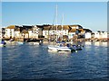
High tide at Teignmouth
The row of houses along the strand overlooking the harbour.
Image: © Alan Hunt
Taken: 12 Jun 2014
0.01 miles
8
Flood wall going up at No.9 Forester's Terrace
A concrete floodwall is being clad with local stone, requiring a diversion of the public right of way along the back beach.
Image: © Robin Stott
Taken: 5 May 2012
0.01 miles
9
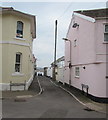
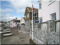
Marine Terrace, Teignmouth
Narrow street on the west side of the Strand. The Foresters Terrace name sign is on the left.
Image: © Jaggery
Taken: 21 Apr 2016
0.01 miles
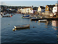
10
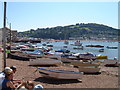
Teignmouth - boats on the Strand foreshore
Shaldon can be seen in the distance, across the Teign estuary.
Image: © Roy Parkhouse
Taken: 3 Aug 2002
0.01 miles