IMAGES TAKEN NEAR TO
French Street, TEIGNMOUTH, TQ14 8ST
Introduction
This page details the photographs taken nearby to French Street, TQ14 8ST by members of the Geograph project.
The Geograph project started in 2005 with the aim of publishing, organising and preserving representative images for every square kilometre of Great Britain, Ireland and the Isle of Man.

There are currently over 7.5m images from over14,400 individuals and you can help contribute to the project by visiting https://www.geograph.org.uk
Image Map
Images are licensed for reuse under creativecommons.org/licenses/by-sa/2.0
Notes
- Clicking on the map will re-center to the selected point.
- The higher the marker number, the further away the image location is from the centre of the postcode.
Image Listing (1412 Images Found)
Images are licensed for reuse under creativecommons.org/licenses/by-sa/2.0
Image
Details
Distance
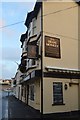
1
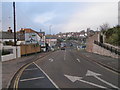
Road junction in Teignmouth near the railway station
Image: © Rob Purvis
Taken: 30 Dec 2008
0.01 miles
2
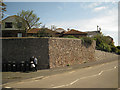
Retaining wall, Brook Street
The residential development above is Alberta Court. The road is part of the one-way Brook Street / Myrtle Hill gyratory.
Image: © Robin Stott
Taken: 6 May 2012
0.01 miles
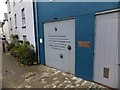
3
Approaching Teignmouth Museum and Exeter Road
Image: © John C
Taken: 26 Apr 2018
0.01 miles
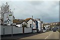
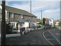
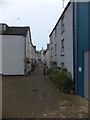
4
French Street
Teignmouth railway station can be seen in the distance. The rebuilt museum is at the end of the street on the left.
Image: © Robin Stott
Taken: 21 May 2011
0.01 miles
6
Inscriptions in French Street, Teignmouth
French Street is now a pedestrian area. The inscriptions recall the French invasive raid on Teignmouth in 1690
Image: © David Smith
Taken: 29 Sep 2013
0.01 miles
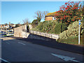
7
Stone-faced houses, St Michael's Mews, Brook Street, Teignmouth
Image: © Robin Stott
Taken: 20 Aug 2012
0.01 miles
8
Pedestrian ramp and gateway to Alberta Court, Teignmouth
Alberta Court and the United Reformed Church occupy the Dawlish Road / Myrtle Hill / Brook Street gyratory northeast of the town centre.
Image: © Robin Stott
Taken: 19 Jan 2014
0.01 miles
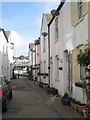
9
French Street, Teignmouth
A narrow street which is now a pedestrian area. The street has memorials to the French invasive raid on Teignmouth in 1690
Image: © David Smith
Taken: 29 Sep 2013
0.01 miles
10
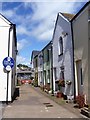
French Street
This street of plain cottages is named in honour of the French 'invasion' of Teignmouth in July, 1690 - it was the last place in England to be invaded by a foreign power. More details at: https://en.wikipedia.org/wiki/Teignmouth
Image: © Michael Dibb
Taken: 27 May 2017
0.02 miles