IMAGES TAKEN NEAR TO
Ashleigh Rise, TEIGNMOUTH, TQ14 8QZ
Introduction
This page details the photographs taken nearby to Ashleigh Rise, TQ14 8QZ by members of the Geograph project.
The Geograph project started in 2005 with the aim of publishing, organising and preserving representative images for every square kilometre of Great Britain, Ireland and the Isle of Man.

There are currently over 7.5m images from over14,400 individuals and you can help contribute to the project by visiting https://www.geograph.org.uk
Image Map (Loading...)


Getting Data...Please wait
Leaflet Map data © OpenStreetMap
Images are licensed for reuse under creativecommons.org/licenses/by-sa/2.0
Notes
- Clicking on the map will re-center to the selected point.
- The higher the marker number, the further away the image location is from the centre of the postcode.
Image Listing (57 Images Found)
Images are licensed for reuse under creativecommons.org/licenses/by-sa/2.0
Image
Details
Distance
1
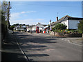
Local shops, Ashleigh Way
Another dauntingly steep road up into Teignmouth's modern estates. Postbox number TQ14 62.
Image: © Robin Stott
Taken: 6 May 2012
0.05 miles
2
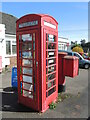
Phone and letter box by Ashleigh Road post office
Outside the post office, the phone box is now converted. Inside are many things for local interest, including books and adverts for volunteering.
Image: © Neil Owen
Taken: 30 Mar 2024
0.05 miles
3
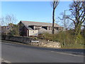
Trinity School, Teignmouth
An independent co-educational school founded 1979 with over 630 pupils from nursery to sixth form, see http://www.trinityschool.co.uk/ and the "development" section.
Image: © Jennifer Vaughan
Taken: 8 Feb 2006
0.06 miles
4

In a garden, a brook drops down to pass under New Road
This will be the Brimley Brook or one of its tributary streams.
Image: © Robin Stott
Taken: 10 Dec 2012
0.08 miles
5
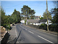
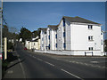
New Road looking east
New Road looks like a fairly old suburban road. It runs around the contours, mostly, connecting the Exeter Road and the Dawlish Road and forming the upslope boundary of Teignmouth's Regency and Victorian suburbs. In the centre of the picture is an average-sized Monterey Cypress (Cupressus macrocarpa), a species that grows well on the southwest's coasts.
Image: © Robin Stott
Taken: 6 May 2012
0.09 miles
6
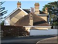
Trevose, 9 New Road
An isolated example of the polychrome brickwork seen lower down the Brimley valley.
Image: © Robin Stott
Taken: 6 May 2012
0.10 miles
7
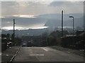
The view down Maudlin Drive, Teignmouth
I'd taken one of the town buses for the steep mile up from the town centre to these hillside residential roads, turned round and was stunned by the view, the reflected sun and the procession of cloud shadows over the sea. In the distance is Thatcher Rock and Hope's Nose, the northern tip of Torbay. Closer to the camera is the Ness across the River Teign, and Teignmouth pier on the left.
Image: © Robin Stott
Taken: 11 Dec 2012
0.10 miles
8
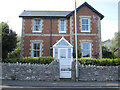
Large house of cream brick, corner of New Road and Stapleford Drive
It is believed that the cream bricks seen in Teignmouth and elsewhere where made at a brickworks in Kingsteignton using the fine clay from the Bovey Basin. The bricks were hard and strong, more like a ceramic. There are many houses in the area of orange brick that use courses of cream brick for strength at corners and for door and window surrounds. Far fewer houses are built of the cream brick, with details in orange brick or the pale grey Devonian limestone.
Image: © Robin Stott
Taken: 10 Dec 2012
0.13 miles
9
New flats, New Road, corner of Stapleford Drive
Image: © Robin Stott
Taken: 6 May 2012
0.14 miles
10
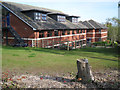
Trinity School, new senior accommodation
The view from the corner of New Road and Buckeridge Road.
Image: © Robin Stott
Taken: 6 May 2012
0.14 miles