IMAGES TAKEN NEAR TO
Buckeridge Avenue, TEIGNMOUTH, TQ14 8LU
Introduction
This page details the photographs taken nearby to Buckeridge Avenue, TQ14 8LU by members of the Geograph project.
The Geograph project started in 2005 with the aim of publishing, organising and preserving representative images for every square kilometre of Great Britain, Ireland and the Isle of Man.

There are currently over 7.5m images from over14,400 individuals and you can help contribute to the project by visiting https://www.geograph.org.uk
Image Map
Images are licensed for reuse under creativecommons.org/licenses/by-sa/2.0
Notes
- Clicking on the map will re-center to the selected point.
- The higher the marker number, the further away the image location is from the centre of the postcode.
Image Listing (89 Images Found)
Images are licensed for reuse under creativecommons.org/licenses/by-sa/2.0
Image
Details
Distance
1
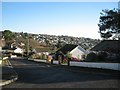
Looking east-northeast from the top of Hawkins Drive
Image: © Robin Stott
Taken: 10 Dec 2012
0.05 miles
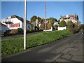
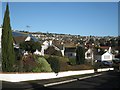
2
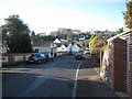
View along Buckeridge Avenue to Exeter Road on the skyline
Image: © Robin Stott
Taken: 10 Dec 2012
0.05 miles
3
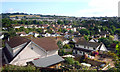
View of Part of Teignmouth
Just a general view of this residential part of town from an overlook beside the Exeter Road.
Image: © Des Blenkinsopp
Taken: 18 Jun 2011
0.06 miles
4
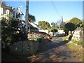
Elmonte Close, a private road off Buckeridge Road
Private roads are a feature of Teignmouth's older suburbs. Elmonte Close is no more than a shared drive; some private roads are more substantial while at the other end of the spectrum they are grassy tracks.
Image: © Robin Stott
Taken: 10 Dec 2012
0.06 miles
5
Glenside Close, a private road off Buckeridge Road
Private roads are a feature of Teignmouth's older suburbs. Glenside Close is relatively substantial; some private roads are more like shared drives, while at the other end of the spectrum they are grassy tracks.
Balconies enjoy sea views on these steep south-facing hillsides.
Image: © Robin Stott
Taken: 10 Dec 2012
0.07 miles
6
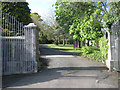
Gates of Trinity School, Buckeridge Road
Newish gates on old, Devonian limestone pillars. A pillar to the left carries the name Notre Dame Convent St Josephs Image
Image: © Robin Stott
Taken: 6 May 2012
0.07 miles
7
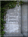
Pillar to flank wall, Trinity School entrance
Metal lettering discloses an earlier incarnation: Notre Dame Convent St Josephs.
Image: © Robin Stott
Taken: 6 May 2012
0.07 miles
8
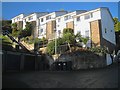
Nos 24-28 The Mount
The Mount estate on a very steep slope is one of Teignmouth's more extreme residential impositions on the landscape. One's heart goes out to the architect, the builder and the residents who have had to cope at various times with the big changes of level.
Image: © Robin Stott
Taken: 10 Dec 2012
0.07 miles
9
Looking north-northeast across the top of Hawkins Drive
Image: © Robin Stott
Taken: 10 Dec 2012
0.07 miles
10

Looking north across Hawkins Drive, Teignmouth
Seen from the Exeter Road the roofs of Hawkins Drive are below the camera. New Road crosses the picture below centre with the cemetery beyond it in Image Beyond that, new estates have climbed relentlessly up these steep hillsides. The highest line of houses is Maudlin Drive with the fields of Holcombe Down on the ridge above in Image It seems to me important that these fields are not built on; they make the town feel contained. To the east, the houses reach the skyline and could go on for ever.
Image: © Robin Stott
Taken: 15 Mar 2016
0.07 miles