IMAGES TAKEN NEAR TO
Barham Avenue, TEIGNMOUTH, TQ14 8GG
Introduction
This page details the photographs taken nearby to Barham Avenue, TQ14 8GG by members of the Geograph project.
The Geograph project started in 2005 with the aim of publishing, organising and preserving representative images for every square kilometre of Great Britain, Ireland and the Isle of Man.

There are currently over 7.5m images from over14,400 individuals and you can help contribute to the project by visiting https://www.geograph.org.uk
Image Map (Loading...)


Getting Data...Please wait
Leaflet Map data © OpenStreetMap
Images are licensed for reuse under creativecommons.org/licenses/by-sa/2.0
Notes
- Clicking on the map will re-center to the selected point.
- The higher the marker number, the further away the image location is from the centre of the postcode.
Image Listing (121 Images Found)
Images are licensed for reuse under creativecommons.org/licenses/by-sa/2.0
Image
Details
Distance
1
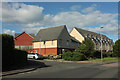
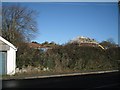
Part of the Marine View estate nearing completion, Teignmouth
Bovis is developing the last few open fields by New Road. So the houses creep up the hillside towards the skyline. A sea view is worth any price to some.
Image: © Robin Stott
Taken: 10 Dec 2012
0.03 miles
2
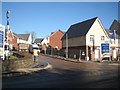
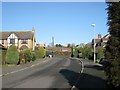
Elizabethan Way, Teignmouth
Looking up the road seen in Image
Image: © Derek Harper
Taken: 10 Jul 2020
0.03 miles
3
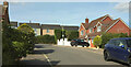
Junction on New Road, Teignmouth
Elizabethan Way leads into the new estate Robin has shown at Image
Image: © Derek Harper
Taken: 10 Jul 2020
0.03 miles
4
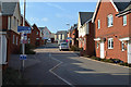
North and uphill on Amethyst Drive, Marine View estate off New Road, north Teignmouth
This new estate by Bovis encroaches further up the green hillside that visually contains the town.
Image: © Robin Stott
Taken: 15 Mar 2016
0.03 miles
5
House-building north of New Road, Teignmouth
Bovis is developing an estate called Marine View on the last few open fields by New Road. Sea views sell houses here, I have no doubt.
Image: © Robin Stott
Taken: 10 Dec 2012
0.04 miles
6
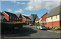
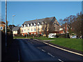
Top of Highgrove Park, nearing New Road, Teignmouth
Highgrove Park is an established residential estate on a coronary-inducing slope, running down to St Scholastica's and the Dawlish Road. Here at the top is a view of the last open fields by New Road in the course of development by Bovis as the Marine View estate.
Image: © Robin Stott
Taken: 10 Dec 2012
0.05 miles
7
Highgrove Park, Teignmouth
Reaching the junction with New Road.
Image: © Derek Harper
Taken: 17 Sep 2022
0.05 miles
8
New residential development, east end of New Road, Teignmouth
Bovis is developing hillside fields for its Marine View housing estate north of New Road Image It could be argued that the desire for a sea view has driven Teignmouth's past and present development.
Image: © Robin Stott
Taken: 19 Jan 2014
0.05 miles
9
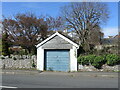
Garage on New Road
A small garage opens out onto New Road, apart from any nearby housing. Close by on the wall is a benchmark - see Image
Image: © Neil Owen
Taken: 30 Mar 2024
0.07 miles
10
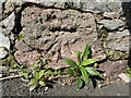
New Road benchmark
A rather scruffy cutmark rests in the stone wall of New Road. See https://www.bench-marks.org.uk/bm217359 for the entry in the Benchmark Database and Image] for a location view.
Image: © Neil Owen
Taken: 30 Mar 2024
0.07 miles