IMAGES TAKEN NEAR TO
Long Lane, TEIGNMOUTH, TQ14 0HB
Introduction
This page details the photographs taken nearby to Long Lane, TQ14 0HB by members of the Geograph project.
The Geograph project started in 2005 with the aim of publishing, organising and preserving representative images for every square kilometre of Great Britain, Ireland and the Isle of Man.

There are currently over 7.5m images from over14,400 individuals and you can help contribute to the project by visiting https://www.geograph.org.uk
Image Map
Images are licensed for reuse under creativecommons.org/licenses/by-sa/2.0
Notes
- Clicking on the map will re-center to the selected point.
- The higher the marker number, the further away the image location is from the centre of the postcode.
Image Listing (132 Images Found)
Images are licensed for reuse under creativecommons.org/licenses/by-sa/2.0
Image
Details
Distance
1
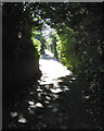
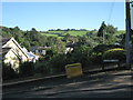
Looking up Pound Lane, Ringmore
From Higher Ringmore Road lanes climb steeply up, as here, to join Long Lane, or down into the brook valley.
Image: © Robin Stott
Taken: 20 Aug 2012
0.02 miles
2
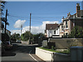
East end of Coombe Road, Ringmore
Coombe Road is to the left. The left turn into Long Lane is hidden. The carriageway with the cone appears to be a private access. This part of south Devon is notable for its wirescapes.
Image: © Robin Stott
Taken: 15 Sep 2011
0.06 miles
3
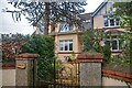
Shaldon : Homefield
Homefield seen on Long Lane.
Image: © Lewis Clarke
Taken: 31 Dec 2021
0.06 miles
4
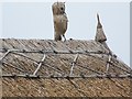
Roof detail, Old Stoke House
Detail of the thatchers art.
Image: © Maigheach-gheal
Taken: 18 Aug 2008
0.06 miles
5
View to Butterfly Lane from the west end of Laurel Lane, Ringmore
Butterfly Lane runs along the ridge that encloses the Ringmore valley. This is a view back down: Image
Image: © Robin Stott
Taken: 20 Aug 2012
0.06 miles
6
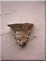
Architectural feature on Old Stoke House
Detail on Image
Image: © Maigheach-gheal
Taken: 18 Aug 2008
0.06 miles
7
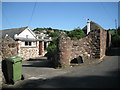
Entrance to Barn End, Higher Ringmore Road, Ringmore
Note the old sandstone walls.
Image: © Robin Stott
Taken: 20 Aug 2012
0.07 miles
8
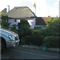
House on the corner of Laurel Lane, Ringmore
According to the local street map, Laurel Farm. The east end of Laurel Lane is as steep or steeper than some roads in Teignmouth, for example: Image
Image: © Robin Stott
Taken: 20 Aug 2012
0.07 miles
9
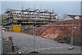
Shaldon : Loaning
Construction takes place off Coombe Road.
Image: © Lewis Clarke
Taken: 31 Dec 2021
0.07 miles
10
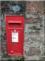
Postbox, Ringmore
George VI postbox.
Image: © Maigheach-gheal
Taken: 18 Aug 2008
0.07 miles