IMAGES TAKEN NEAR TO
Blythswood Crescent, TORQUAY, TQ1 3HJ
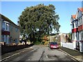
Introduction
This page details the photographs taken nearby to Blythswood Crescent, TQ1 3HJ by members of the Geograph project.
The Geograph project started in 2005 with the aim of publishing, organising and preserving representative images for every square kilometre of Great Britain, Ireland and the Isle of Man.

There are currently over 7.5m images from over14,400 individuals and you can help contribute to the project by visiting https://www.geograph.org.uk
Image Map
Images are licensed for reuse under creativecommons.org/licenses/by-sa/2.0
Notes
- Clicking on the map will re-center to the selected point.
- The higher the marker number, the further away the image location is from the centre of the postcode.
Image Listing (261 Images Found)
Images are licensed for reuse under creativecommons.org/licenses/by-sa/2.0
Image
Details
Distance
1
Cedar Court Road, Torquay
A reverse view of the scene in Image, showing more of the old curving wall mentioned, plus two holm oaks beside it.
Image: © Derek Harper
Taken: 12 Jan 2008
0.03 miles
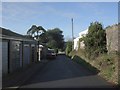
2
Cedar Court Road, Torquay
A cul-de-sac (by virtue of a wall, round the corner to the left, cutting it off from Victoria Park Road in Plainmoor) off St Marychurch Road. The older wall to the left here must be the boundary of an old property, probably the building on St Marychurch Road that is now a dental surgery.
Image: © Derek Harper
Taken: 12 Jan 2008
0.03 miles
3
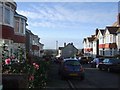
Cedar Court Road, Torquay
Cedar Court Road is a T-shaped cul-de-sac; this is the top left of the T, which ends in a wall separating it from Victoria Park Road behind the camera. Early camellias bloom by one of the bow-fronted semis.
Image: © Derek Harper
Taken: 12 Jan 2008
0.04 miles
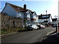
4
St John Ambulance, Torquay
St John House is on St Marychurch Road , just south of Plainmoor. Locksley Close leads to two pairs of modern semis, perhaps built in the former grounds.
Image: © Derek Harper
Taken: 12 Jan 2008
0.04 miles
5
Cedar Court Road, Torquay
The stretch of Image that runs down to the junction with St Marychurch Road, past garages and the wall mentioned in that photo.
Image: © Derek Harper
Taken: 12 Jan 2008
0.05 miles
6
Service road, Plainmoor
Seen across Victoria Park Road, and continuing the line of the alley shown in
Image], but not for very far. It ends in a small parking area and gives access to garages at the rear of properties on St Marychurch Road. The dark clouds are still approaching.
Image: © Derek Harper
Taken: 9 Apr 2016
0.05 miles
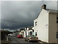
7
Bronshill Court, Torquay
A detached house on Bronshill Road.
Image: © Derek Harper
Taken: 4 Dec 2021
0.06 miles
8
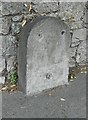
Old Milestone by St Marychurch Road, Plainmoor, Torquay
Stone post (plate lost) by the UC road, in parish of TORQUAY (TORBAY District), St Marychurch Road, by No. 78, The Pines, opposite Cedar Court Road, on pavement against wall, on East side of road. Torquay iron plate stone, erected by the Dartmouth, Torquay & Shaldon turnpike trust in the 19th century.
Inscription once read:-
(Teignmouth)
(7)
Devon & Dartmoor HER listed.
HER Number: MDV123850 https://www.heritagegateway.org.uk/Gateway/Results_Single.aspx?uid=MDV123850&resourceID=104
Milestone Society National ID: DV_TQMC01
Image: © Alan Rosevear
Taken: 24 May 2012
0.06 miles
9
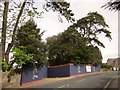
Development site, St Marychurch Road, Torquay
The road frontage of the site shown in Image], with construction hoarding beneath the trees.
Image: © Derek Harper
Taken: 12 Apr 2014
0.06 miles
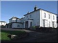
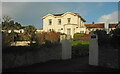
10
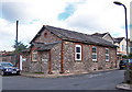
Former school?
This building and stone walled yard in Victoria Park Road is now owned by a local builder and used as a store and depot. It has the look of having been originally built as a school.
Image: © Richard Dorrell
Taken: 29 Aug 2010
0.06 miles