IMAGES TAKEN NEAR TO
Manaton, NEWTON ABBOT, TQ13 9UA
Introduction
This page details the photographs taken nearby to TQ13 9UA by members of the Geograph project.
The Geograph project started in 2005 with the aim of publishing, organising and preserving representative images for every square kilometre of Great Britain, Ireland and the Isle of Man.

There are currently over 7.5m images from over14,400 individuals and you can help contribute to the project by visiting https://www.geograph.org.uk
Image Map
Images are licensed for reuse under creativecommons.org/licenses/by-sa/2.0
Notes
- Clicking on the map will re-center to the selected point.
- The higher the marker number, the further away the image location is from the centre of the postcode.
Image Listing (40 Images Found)
Images are licensed for reuse under creativecommons.org/licenses/by-sa/2.0
Image
Details
Distance
3
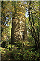
Freelands Tower
The tower which was built in the early 1900’s as an observatory and then used during World War II by the Home Guard as a look out post. The tower is private and is unstable, the interior wooden staging having collapsed some time ago.
Image: © Guy Wareham
Taken: 1 Nov 2010
0.06 miles
5
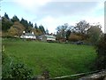
Field to the east of Water
A small field and a solitary horse grazing in it
Image: © David Smith
Taken: 4 Nov 2019
0.08 miles
6
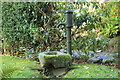
Water pump
Standing in the front garden of a cottage in Water.
Image: © Guy Wareham
Taken: 1 Nov 2010
0.10 miles
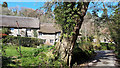
10
Footpath by Hayne Brook
Manaton Footpath 29 runs alongside the brook (on the left behind the trees) from just below Deal Farm, and crosses it on stepping stones just before reaching the road from Water to Bovey Tracey.
Image: © Derek Harper
Taken: 30 Oct 2012
0.12 miles