IMAGES TAKEN NEAR TO
Pethybridge, NEWTON ABBOT, TQ13 9TG
Introduction
This page details the photographs taken nearby to Pethybridge, TQ13 9TG by members of the Geograph project.
The Geograph project started in 2005 with the aim of publishing, organising and preserving representative images for every square kilometre of Great Britain, Ireland and the Isle of Man.

There are currently over 7.5m images from over14,400 individuals and you can help contribute to the project by visiting https://www.geograph.org.uk
Image Map
Images are licensed for reuse under creativecommons.org/licenses/by-sa/2.0
Notes
- Clicking on the map will re-center to the selected point.
- The higher the marker number, the further away the image location is from the centre of the postcode.
Image Listing (187 Images Found)
Images are licensed for reuse under creativecommons.org/licenses/by-sa/2.0
Image
Details
Distance
1
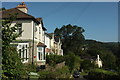
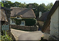
Houses on Pethybridge
The four on the left (three in a terrace and a detached) are seen from below in Image The lane through the hamlet winds steeply down towards Lustleigh.
Image: © Derek Harper
Taken: 25 Aug 2019
0.01 miles
3
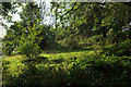
Meadow near Lustleigh
Seen from Lustleigh footpath 2.
Image: © Derek Harper
Taken: 25 Aug 2019
0.06 miles
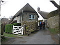
5

Postbox, Lustleigh
George V letters only postbox TQ13 173 is on Pethybridge.
Image: © Derek Harper
Taken: 17 Aug 2022
0.09 miles
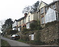
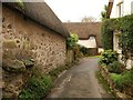
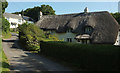
6
Cottages at Pethybridge
A notice reinforces my comments at Image; see also Image Mind you, some people live down this land and presumably have vehicles. Three listed thatched cottages are shown here: most prominent is Cob Cottage, listed as Pethybridge Cottage https://historicengland.org.uk/listing/the-list/list-entry/1166231 . Beside it down the lane is Moorlands https://historicengland.org.uk/listing/the-list/list-entry/1097370 . On the immediate right is Pethybridge Farmhouse, listed as Dartmoor Cottage https://historicengland.org.uk/listing/the-list/list-entry/1334123 (see Image]). The names I've used are those on the current detailed map, but they may have changed again. It may look sleepy and laid back, but you need your wits about you with these names, especially if you're the postie.
Image: © Derek Harper
Taken: 25 Aug 2019
0.09 miles
7
Pethybridge
Best explored on foot; the narrow and sharply winding road twists steeply up from Lustleigh before negotiating these walls in the old centre of the hamlet. See Image] for more details.
Image: © Derek Harper
Taken: 14 Dec 2008
0.10 miles
8
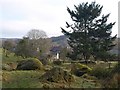
Boulders, Town Orchard, Lustleigh
Looking in the opposite direction from a similar spot to where Image was taken. Large granite boulders line the course of Lustleigh Footpath 35. Image is beneath the conifer. Image can be seen on the left.
Image: © Derek Harper
Taken: 14 Dec 2008
0.10 miles
9
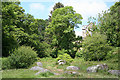
Lustleigh: end of the orchard
A public path runs through this 'orchard' or paddock and leads to Sharpitor and Lustleigh Cleave
Image: © Martin Bodman
Taken: 2 Jun 2011
0.11 miles
10
Pethybridge Farmhouse
Listed at https://historicengland.org.uk/listing/the-list/list-entry/1334123 as Dartmoor Cottage.
Image: © Derek Harper
Taken: 25 Aug 2019
0.11 miles