Cottages at Pethybridge
Introduction
The photograph on this page of Cottages at Pethybridge by Derek Harper as part of the Geograph project.
The Geograph project started in 2005 with the aim of publishing, organising and preserving representative images for every square kilometre of Great Britain, Ireland and the Isle of Man.

There are currently over 7.5m images from over 14,400 individuals and you can help contribute to the project by visiting https://www.geograph.org.uk
Cottages at Pethybridge
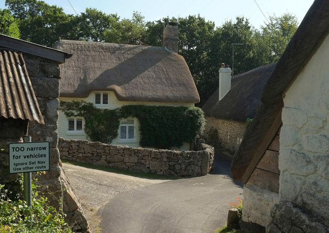
Image: © Derek Harper Taken: 25 Aug 2019
A notice reinforces my comments at Image; see also Image Mind you, some people live down this land and presumably have vehicles. Three listed thatched cottages are shown here: most prominent is Cob Cottage, listed as Pethybridge Cottage https://historicengland.org.uk/listing/the-list/list-entry/1166231 . Beside it down the lane is Moorlands https://historicengland.org.uk/listing/the-list/list-entry/1097370 . On the immediate right is Pethybridge Farmhouse, listed as Dartmoor Cottage https://historicengland.org.uk/listing/the-list/list-entry/1334123 (see Image]). The names I've used are those on the current detailed map, but they may have changed again. It may look sleepy and laid back, but you need your wits about you with these names, especially if you're the postie.
Images are licensed for reuse under creativecommons.org/licenses/by-sa/2.0
Image Location
Latitude
50.616101
Longitude
-3.725249