IMAGES TAKEN NEAR TO
Churchfields Drive, NEWTON ABBOT, TQ13 9QU
Introduction
This page details the photographs taken nearby to Churchfields Drive, TQ13 9QU by members of the Geograph project.
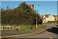
The Geograph project started in 2005 with the aim of publishing, organising and preserving representative images for every square kilometre of Great Britain, Ireland and the Isle of Man.

There are currently over 7.5m images from over14,400 individuals and you can help contribute to the project by visiting https://www.geograph.org.uk
Image Map
Images are licensed for reuse under creativecommons.org/licenses/by-sa/2.0
Notes
- Clicking on the map will re-center to the selected point.
- The higher the marker number, the further away the image location is from the centre of the postcode.
Image Listing (218 Images Found)
Images are licensed for reuse under creativecommons.org/licenses/by-sa/2.0
Image
Details
Distance
1
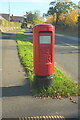
Postbox, Bovey Tracey
Elizabeth II postbox TQ13 251 is beside the B3344 Le Molay-Littry Way.
Image: © Derek Harper
Taken: 14 Nov 2021
0.07 miles
2
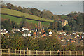
Bovey Tracey from Chapple Road
A detail of Image The large building to the right of the church is Devon House, originally the Devon House of Mercy. In the foreground is a walker on Bovey Tracey Footpath 8. Taken from the Templer Way.
Image: © Derek Harper
Taken: 14 Nov 2021
0.10 miles
3
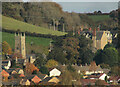
Bovey Tracey from Chapple Road
A detail of Image], with the grade I listed Church of St Peter and St Paul and St Thomas of Canterbury https://historicengland.org.uk/listing/the-list/list-entry/1334077 and Devon House https://historicengland.org.uk/listing/the-list/list-entry/1097430 . The church is shown in most of the photos at http://www.geograph.org.uk/search.php?i=146825282 .
Image: © Derek Harper
Taken: 14 Nov 2021
0.10 miles
4
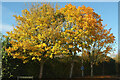
Trees, De Tracey Park, Bovey Tracey
Autumnal Acers on a road leading to a network of cul-de-sacs, seen from Le Molay-Littry Way.
Image: © Derek Harper
Taken: 14 Nov 2021
0.11 miles
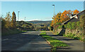
5
Churchfields Drive, Bovey Tracey
At the eastern junction with the B3344. The estate road winds around a good deal before rejoining Le Molay-Littry Way some 150 metres west.
Image: © Derek Harper
Taken: 14 Nov 2021
0.12 miles
6
Le Molay-Littry Way, Bovey Tracey
Approaching the junction on the right with De Tracey Park.
Image: © Derek Harper
Taken: 14 Nov 2021
0.12 miles
7
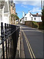
East Street, Bovey Tracey
Looking east along the street. The house on the right, the Manor House, has mid C19 external neo-Tudor features, but there is an older house within.
Image: © Derek Harper
Taken: 7 Oct 2006
0.13 miles
8
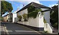
East Street, Bovey Tracey
Houses on East Street. On the right is an outbuilding of the Manor House.
Image: © Derek Harper
Taken: 7 Oct 2006
0.13 miles
9
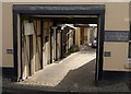
Yard off East Street, Bovey Tracey
Winter sunlight enters a timbered passageway leading off East Street.
Image: © Derek Harper
Taken: 12 Dec 2010
0.14 miles
10
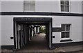
Bovey Tracey : The Old Wheelwrights
A small business premises on East Street.
Image: © Lewis Clarke
Taken: 12 Aug 2013
0.14 miles