IMAGES TAKEN NEAR TO
Hennock, Bovey Tracey, NEWTON ABBOT, TQ13 9QE
Introduction
This page details the photographs taken nearby to TQ13 9QE by members of the Geograph project.
The Geograph project started in 2005 with the aim of publishing, organising and preserving representative images for every square kilometre of Great Britain, Ireland and the Isle of Man.

There are currently over 7.5m images from over14,400 individuals and you can help contribute to the project by visiting https://www.geograph.org.uk
Image Map
Images are licensed for reuse under creativecommons.org/licenses/by-sa/2.0
Notes
- Clicking on the map will re-center to the selected point.
- The higher the marker number, the further away the image location is from the centre of the postcode.
Image Listing (88 Images Found)
Images are licensed for reuse under creativecommons.org/licenses/by-sa/2.0
Image
Details
Distance
1
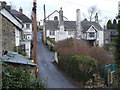
Longlands, Hennock
Looking northeast across Church Road from the churchyard to the 15th century Longlands with its high chimney stacks and timbered jetty https://historicengland.org.uk/listing/the-list/list-entry/1165988 . Above its roof is the gable of The Old Chapel (Wesleyan). See also Image], taken 13 years later.
Image: © Derek Harper
Taken: 25 Mar 2006
0.01 miles
2
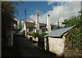
Longlands, Hennock
See also Image; the central stack on the former farmhouse https://historicengland.org.uk/listing/the-list/list-entry/1165988 has been painted since. This is on Church Road, which becomes a private track to a cottage and farm.
Image: © Derek Harper
Taken: 25 Apr 2019
0.01 miles
3
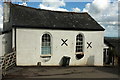
Former chapel, Hennock
This former Wesleyan Methodist chapel was "built in 1833 because of the large influx of workers coming from Cornwall to work in the mines. Constructed on part of a site which used to be an orchard, the Chapel was in use up until about 1952. From then on until about 1970 the building was used as a Sunday school. In the 1970s it was used as a workshop and finally converted to residential use in the 1980s" http://www.hennock.org.uk/hennock_houses.html .
Image: © Derek Harper
Taken: 25 Apr 2019
0.01 miles
4
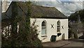
Former chapel, Hennock
Another photo of the former Wesleyan Methodist chapel shown in Image "Built in 1833 because of the large influx of workers coming from Cornwall to work in the mines. Constructed on part of a site which used to be an orchard, the Chapel was in use up until about 1952. From then on until about 1970 the building was used as a Sunday school. In the 1970s it was used as a workshop and finally converted to residential use in the 1980s".
Image: © Derek Harper
Taken: 25 Apr 2019
0.01 miles
5
Path, Hennock
A crossing of grid line is only feet away behind to the left here, and this stretch of Hennock footpath 1 crosses, for 40 metres or so, the northwest corner of this square as it passes the house on the right. The Old Chapel, though, facing the camera across Church Road, is in Image; see Image
Image: © Derek Harper
Taken: 25 Apr 2019
0.02 miles
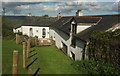
6
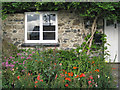
Front garden, Hennock
As with other buildings in the village the mortared rubble walls are two stones: a light-coloured granite and a darker stone, assumed to be volcanic. Photographed just before 7pm BST.
Image: © Robin Stott
Taken: 25 Aug 2011
0.02 miles
9
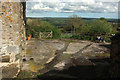
Path, Hennock
Hennock Footpath 8 crosses this area and heads through the timber gate on the left. The view extends over the Teign valley to Haldon.
Image: © Derek Harper
Taken: 25 Apr 2019
0.03 miles
10
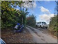
Lane ends and footpath starts, on the north side of Hennock
Image: © Rob Purvis
Taken: 21 Nov 2021
0.03 miles