IMAGES TAKEN NEAR TO
Hennock, Bovey Tracey, NEWTON ABBOT, TQ13 9QB
Introduction
This page details the photographs taken nearby to TQ13 9QB by members of the Geograph project.
The Geograph project started in 2005 with the aim of publishing, organising and preserving representative images for every square kilometre of Great Britain, Ireland and the Isle of Man.

There are currently over 7.5m images from over14,400 individuals and you can help contribute to the project by visiting https://www.geograph.org.uk
Image Map
Images are licensed for reuse under creativecommons.org/licenses/by-sa/2.0
Notes
- Clicking on the map will re-center to the selected point.
- The higher the marker number, the further away the image location is from the centre of the postcode.
Image Listing (81 Images Found)
Images are licensed for reuse under creativecommons.org/licenses/by-sa/2.0
Image
Details
Distance
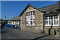
2
Primary School, Hennock
Hennock Community Primary School occupies different buildings along the village street.
Image: © Derek Harper
Taken: 25 Apr 2019
0.02 miles
3
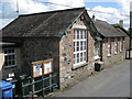
Hennock Primary School
Looking down on it from the children's playground. The walls are of four materials: a local orange brick and two stones: the light-coloured granite and a darker stone seen locally, assumed to be volcanic; the lintels and window cills look like modern concrete.
Image: © Robin Stott
Taken: 25 Aug 2011
0.03 miles
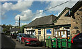
4
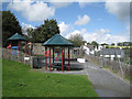
Children's playground, Hennock
It's perched above the main street, opposite the school.
Image: © Robin Stott
Taken: 25 Aug 2011
0.03 miles
5
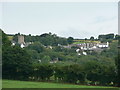
Hennock village and church
Taken from the direction of Warmhill Farm.
Image: © paul dickson
Taken: 8 Jul 2008
0.03 miles
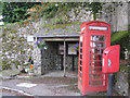
6
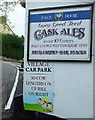
Local measurement, Hennock
I suppose mature cattle are roughly a standard length - maybe 8.5 feet? A more conventional sign appears just up to the left, suggesting the car park is then 60 yards further on. The wall belongs to the Palk Arms.
Image: © Derek Harper
Taken: 25 Apr 2019
0.04 miles
8
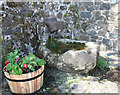
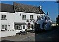
Old Cross base, Hennock
Hennock Cross base, old base by the UC road, in parish of Hennock (Teignbridge District), opposite The Palk Arms PH, East of Vicarage Gatehouse, on granite paving against the wall.
Grade II Listed:-
List Entry Number: 1097384 https://historicengland.org.uk/listing/the-list/list-entry/1097384
Surveyed
Milestone Society National ID: DVTE_HEN
Image: © Alan Rosevear
Taken: 18 Jun 2010
0.04 miles
9
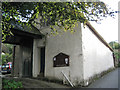
Hennock village hall
A surprisingly overpowering building at the north end of the village, at the junction of Church Lane and Bell Lane.
Image: © Robin Stott
Taken: 25 Aug 2011
0.05 miles