IMAGES TAKEN NEAR TO
Bovey Tracey, NEWTON ABBOT, TQ13 9PT
Introduction
This page details the photographs taken nearby to TQ13 9PT by members of the Geograph project.
The Geograph project started in 2005 with the aim of publishing, organising and preserving representative images for every square kilometre of Great Britain, Ireland and the Isle of Man.

There are currently over 7.5m images from over14,400 individuals and you can help contribute to the project by visiting https://www.geograph.org.uk
Image Map
Images are licensed for reuse under creativecommons.org/licenses/by-sa/2.0
Notes
- Clicking on the map will re-center to the selected point.
- The higher the marker number, the further away the image location is from the centre of the postcode.
Image Listing (5 Images Found)
Images are licensed for reuse under creativecommons.org/licenses/by-sa/2.0
Image
Details
Distance
1

View from Bottor Rock
Looking south by east through the trees from the tor.
Image: © Derek Harper
Taken: 13 Apr 2006
0.03 miles
2
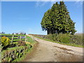
Farm Driveway
This is the start of the private road to Bottor Rock Farm.
Image: © Tony Atkin
Taken: 27 Jan 2013
0.16 miles
3

Bottor Rock
In trees and surrounded by farmland, Bottor is in other ways a typical granite Dartmoor tor. This view looks approximately SSW.
Image: © Derek Harper
Taken: 13 Apr 2006
0.16 miles
4

Bridleway near Hennock
Looking north-west up this old track climbing steeply from the Five Lanes junction. Ramsons growing in abundance.
Image: © Derek Harper
Taken: 13 Apr 2006
0.17 miles
5
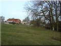
Stickwick Farm, Hennock
View across Stickwick Farm near the Five Lanes cross road, Hennock
Image: © Alan Hunt
Taken: 1 Mar 2010
0.23 miles