IMAGES TAKEN NEAR TO
Challabrook Lane, NEWTON ABBOT, TQ13 9DF
Introduction
This page details the photographs taken nearby to Challabrook Lane, TQ13 9DF by members of the Geograph project.
The Geograph project started in 2005 with the aim of publishing, organising and preserving representative images for every square kilometre of Great Britain, Ireland and the Isle of Man.

There are currently over 7.5m images from over14,400 individuals and you can help contribute to the project by visiting https://www.geograph.org.uk
Image Map
Images are licensed for reuse under creativecommons.org/licenses/by-sa/2.0
Notes
- Clicking on the map will re-center to the selected point.
- The higher the marker number, the further away the image location is from the centre of the postcode.
Image Listing (51 Images Found)
Images are licensed for reuse under creativecommons.org/licenses/by-sa/2.0
Image
Details
Distance
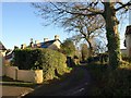
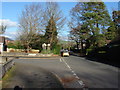
1
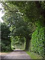
Challabrook Lane
This lane, with oak trees towering above, is a dead end leading to Challabrook Farm from Brimley Road. On the way it passes several houses within gardens; a pair of driveways can be seen on the left.
Image: © Derek Harper
Taken: 6 Sep 2008
0.03 miles
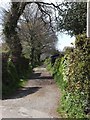
2
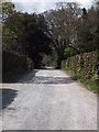
Challabrook Lane
This leads past Challabrook Farm to join Stentiford Lane and the road to Lower Down
Image: © David Smith
Taken: 16 Apr 2012
0.03 miles
3
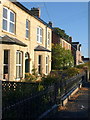
Cottages on Brimley Road
Attractively varied brick cottages on Brimley Road in Bovey Tracey next to the crossing point of the Templer Way.
Image: © Derek Harper
Taken: 24 Oct 2010
0.08 miles
4
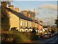
Cottages at Brimley
These brick cottages on Brimley Road must be associated with the pottery industry. On the left is the entrance to the section of bridleway shown in Image, which also shows the rear of the nearest terrace.
Image: © Derek Harper
Taken: 7 Dec 2008
0.08 miles
5
Templer Way, Brimley
The Templer Way approaches Brimley Road along this bridleway, the same one shown in Image, except that this stretch has lost its granite rails.
Image: © Derek Harper
Taken: 7 Dec 2008
0.10 miles
7
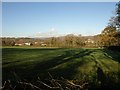
Field near Challabrook Farm
This is the field behind the hedge on the right of Image, so the photo was taken from the Templer Way. Challabrook Farm is on the left. Part of Bovey Tracey can be glimpsed between the trees on the right.
Image: © Derek Harper
Taken: 7 Dec 2008
0.10 miles
8
Ashburton Road
Looking along Ashburton Road in Lower Brimley towards the bridge over the Bovey Tracey bypass.
Image: © Alan Hunt
Taken: 1 Dec 2012
0.12 miles
9
Ashburton Road, Bovey Tracey
Ashburton Road in the Lower Brimley area of Bovey Tracey
Image: © Alan Hunt
Taken: 1 Dec 2012
0.12 miles
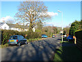
10
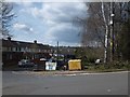
Brimley Vale
A housing development on the west of Bovey Tracey. The grit bin is needed as the slope leads to a bridge which becomes icy in winter.
Image: © David Smith
Taken: 16 Apr 2012
0.12 miles