IMAGES TAKEN NEAR TO
Blackingstone, NEWTON ABBOT, TQ13 8TA
Introduction
This page details the photographs taken nearby to Blackingstone, TQ13 8TA by members of the Geograph project.
The Geograph project started in 2005 with the aim of publishing, organising and preserving representative images for every square kilometre of Great Britain, Ireland and the Isle of Man.

There are currently over 7.5m images from over14,400 individuals and you can help contribute to the project by visiting https://www.geograph.org.uk
Image Map
Images are licensed for reuse under creativecommons.org/licenses/by-sa/2.0
Notes
- Clicking on the map will re-center to the selected point.
- The higher the marker number, the further away the image location is from the centre of the postcode.
Image Listing (17 Images Found)
Images are licensed for reuse under creativecommons.org/licenses/by-sa/2.0
Image
Details
Distance
1
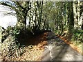
Tree-lined lane beside Beech Tree Farm
Image: © David Gearing
Taken: 1 Nov 2012
0.01 miles
2

Minor road south of Beech Tree Farm
The gate ahead gives access to farmland and to a phone mast on the left; on the right are several beech trees, not the one that gives the farm its name
Image: © David Smith
Taken: 31 Oct 2014
0.01 miles
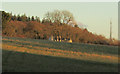
3

Minor road south of Beech Tree Farm (2)
The fields on the left lie between the farmhouse (ahead) and one of its storage barns (beside the photographer). On the right is a large area of woodland
Image: © David Smith
Taken: 31 Oct 2014
0.03 miles
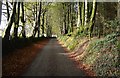
5

Minor road north of Beech Tree Farm
The road is lined with hedgebanks with mature trees on each side
Image: © David Smith
Taken: 31 Oct 2014
0.08 miles
7
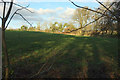
Field, Didworthy
A glimpse into a field from the edge of the extensive plantations along the Trenchford Stream valley.
Image: © Derek Harper
Taken: 3 Dec 2019
0.19 miles
8
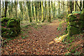
Track through wall east of Moor Barton
One of several old field boundaries in the extensive plantations. Here the path crosses the 300 metre contour.
Image: © Derek Harper
Taken: 3 Dec 2019
0.19 miles
9
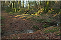
Ford east of Moor Barton
The path up the Trenchford valley crosses a tiny stream.
Image: © Derek Harper
Taken: 3 Dec 2019
0.20 miles
10
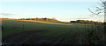
Towards Beech Tree Farm
Looking right from Image
Image: © Derek Harper
Taken: 3 Dec 2019
0.20 miles