IMAGES TAKEN NEAR TO
North Bovey, NEWTON ABBOT, TQ13 8RW
Introduction
This page details the photographs taken nearby to TQ13 8RW by members of the Geograph project.
The Geograph project started in 2005 with the aim of publishing, organising and preserving representative images for every square kilometre of Great Britain, Ireland and the Isle of Man.

There are currently over 7.5m images from over14,400 individuals and you can help contribute to the project by visiting https://www.geograph.org.uk
Image Map
Images are licensed for reuse under creativecommons.org/licenses/by-sa/2.0
Notes
- Clicking on the map will re-center to the selected point.
- The higher the marker number, the further away the image location is from the centre of the postcode.
Image Listing (6 Images Found)
Images are licensed for reuse under creativecommons.org/licenses/by-sa/2.0
Image
Details
Distance
1
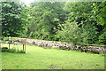
North Bovey: by Bowden Cleave
By the entrance to Bowden Cleave. The main feature is the retaining wall for the millpond or leat serving Bowden Mill. In North Bovey parish
Image: © Martin Bodman
Taken: 23 Jun 2011
0.03 miles
2
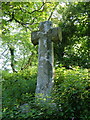
Hele Cross
By a lane junction at Hele Farm. "A fine example of a Maltese Cross" (http://www.dartmoor-crosses.org.uk/hele.htm ).
Image: © Derek Harper
Taken: 7 Jun 2006
0.10 miles
3

Old Wayside Cross - Hele Cross, North Bovey parish
Hele Cross, old head, shaft and base, Starkey No.54 by the UC road, in parish of North Bovey (Teignbridge District), opposite Hele Farm House, high on a bank above the junction.
Grade II listed.
List Entry Number: 1334191 https://historicengland.org.uk/listing/the-list/list-entry/1334191
Scheduled Monument.
List Entry Number: 1009178 https://historicengland.org.uk/listing/the-list/list-entry/1009178
Surveyed
Milestone Society National ID: DVTE_NBV01
Image: © Alan Rosevear
Taken: 2 May 2009
0.11 miles
4
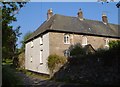
Hele Farmhouse
A view of Image from the other direction, showing the "casements with small panes and pointed heads" http://www.britishlistedbuildings.co.uk/en-85127-hele-farmhouse-north-bovey .
Image: © Derek Harper
Taken: 7 Jun 2006
0.12 miles
5
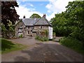
Hele Farmhouse
Seen from the junction of lanes arriving from Watching Place Cross and Barramoor. The farmhouse is a listed building http://www.imagesofengland.org.uk/Details/Default.aspx?id=85127&mode=adv .
Image: © Derek Harper
Taken: 26 May 2009
0.13 miles
6
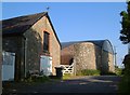
Farm buildings, Hele
The lane from the cross at Hele to Hele Cross begisn by climbing past these buildings on the east side of Image
Image: © Derek Harper
Taken: 7 Jun 2006
0.14 miles