IMAGES TAKEN NEAR TO
Moretonhampstead, NEWTON ABBOT, TQ13 8PS
Introduction
This page details the photographs taken nearby to TQ13 8PS by members of the Geograph project.
The Geograph project started in 2005 with the aim of publishing, organising and preserving representative images for every square kilometre of Great Britain, Ireland and the Isle of Man.

There are currently over 7.5m images from over14,400 individuals and you can help contribute to the project by visiting https://www.geograph.org.uk
Image Map
Images are licensed for reuse under creativecommons.org/licenses/by-sa/2.0
Notes
- Clicking on the map will re-center to the selected point.
- The higher the marker number, the further away the image location is from the centre of the postcode.
Image Listing (4 Images Found)
Images are licensed for reuse under creativecommons.org/licenses/by-sa/2.0
Image
Details
Distance
1
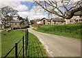
Linscott
The farm is on the winding lane that runs roughly parallel to the A382 between Moretonhampstead and Easton Cross, but on the other side of the valley.
Image: © Derek Harper
Taken: 9 Apr 2014
0.02 miles
2
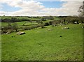
Fields at Linscott
Looking to the left from the spot where Image was taken, with rocks outcropping amidst the pasture. Across the valley is Sainthill.
Image: © Derek Harper
Taken: 9 Apr 2014
0.04 miles
3
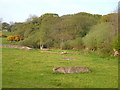
Field and wood near Linscott
Granite outcrops in a field beside a predominantly oak wood.
Image: © Derek Harper
Taken: 12 May 2006
0.11 miles
4
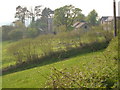
Linscott
Part of the farm seen from along the lane to the east, at 18:53.
Image: © Derek Harper
Taken: 12 May 2006
0.12 miles