IMAGES TAKEN NEAR TO
Station Road, NEWTON ABBOT, TQ13 8NQ
Introduction
This page details the photographs taken nearby to Station Road, TQ13 8NQ by members of the Geograph project.
The Geograph project started in 2005 with the aim of publishing, organising and preserving representative images for every square kilometre of Great Britain, Ireland and the Isle of Man.

There are currently over 7.5m images from over14,400 individuals and you can help contribute to the project by visiting https://www.geograph.org.uk
Image Map
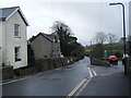
Images are licensed for reuse under creativecommons.org/licenses/by-sa/2.0
Notes
- Clicking on the map will re-center to the selected point.
- The higher the marker number, the further away the image location is from the centre of the postcode.
Image Listing (305 Images Found)
Images are licensed for reuse under creativecommons.org/licenses/by-sa/2.0
Image
Details
Distance
2
![Unitarian chapel [3]](https://s1.geograph.org.uk/geophotos/05/93/28/5932805_5d6b1904_120x120.jpg)
Unitarian chapel [3]
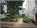
Some of the graves in the chapel's burial ground.
Image: © Michael Dibb
Taken: 24 Sep 2018
0.06 miles
3
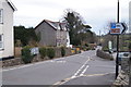
Station Road, Moretonhampstead.
Moretonhampstead station was a short distance outside the village, and lost its passenger service in 1959 and the goods service in 1964. Ironically the station site is now used by a road haulage company! See http://www.disused-stations.org.uk/m/moretonhampstead/index.shtml for a history of the station and the railway and for photographs of the station when in use and more recently.
Image: © Colin Pyle
Taken: 3 Apr 2010
0.06 miles
4
Cross Chapel, Moretonhampstead
Unitarian Chapel dating from 1802 https://historicengland.org.uk/listing/the-list/list-entry/1097209?section=official-list-entry
Image: © Jonathan Thacker
Taken: 8 Oct 2022
0.06 miles
5
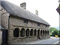
Almshouses, Moretonhampstead
They stand on Cross Street, in front of the church of St Andrew. The date stone says 1637 but is thought to be the remodelling of an earlier building, possibly part of the mediaeval hospital founded here in 1451.
Image: © Penny Mayes
Taken: 28 Jun 2006
0.06 miles
6
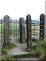
Kissing Gate, Moretonhampstead
This old stone and iron gate leads onto the recreation ground behind the church.
Image: © Penny Mayes
Taken: 28 Jun 2006
0.06 miles
7
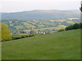
Moretonhampstead from below Marden Down
The church stands out prominently in this late evening view from the lane below Marden Down. Easdon Down is the moorland beyond.
Image: © Derek Harper
Taken: 5 Jun 2006
0.06 miles
8
![Unitarian chapel [2]](https://s0.geograph.org.uk/geophotos/05/93/28/5932804_ff2ce20d_120x120.jpg)
Unitarian chapel [2]
Some of the graves in the chapel's burial ground.
Image: © Michael Dibb
Taken: 24 Sep 2018
0.06 miles
9
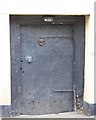
Door, Mearsdon Manor, Moretonhampstead
Image: © Maigheach-gheal
Taken: 17 Aug 2008
0.06 miles
10
![Unitarian chapel [1]](https://s3.geograph.org.uk/geophotos/05/93/28/5932803_bedcb388_120x120.jpg)
Unitarian chapel [1]
Built in 1802, the chapel retains some original internal fittings. Listed, grade II, with details at: https://historicengland.org.uk/listing/the-list/list-entry/1097209
Image: © Michael Dibb
Taken: 24 Sep 2018
0.07 miles