IMAGES TAKEN NEAR TO
Chagford, NEWTON ABBOT, TQ13 8JX
Introduction
This page details the photographs taken nearby to TQ13 8JX by members of the Geograph project.
The Geograph project started in 2005 with the aim of publishing, organising and preserving representative images for every square kilometre of Great Britain, Ireland and the Isle of Man.

There are currently over 7.5m images from over14,400 individuals and you can help contribute to the project by visiting https://www.geograph.org.uk
Image Map
Images are licensed for reuse under creativecommons.org/licenses/by-sa/2.0
Notes
- Clicking on the map will re-center to the selected point.
- The higher the marker number, the further away the image location is from the centre of the postcode.
Image Listing (17 Images Found)
Images are licensed for reuse under creativecommons.org/licenses/by-sa/2.0
Image
Details
Distance
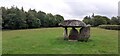
4
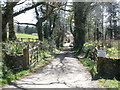
Lane at Shilstone
The lane is heading away from the hamlet towards Stone Cross.
Image: © Derek Harper
Taken: 11 Sep 2009
0.09 miles
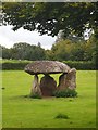
5
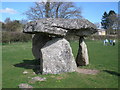
Spinsters Rock
Ancient burial site.
Image: © Peter Mackenzie
Taken: 19 Jun 2021
0.09 miles
6
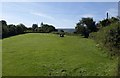
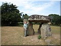
Spinster's Rock
Image in the context of its field, a meadow beside the lane at Shilstone. The lane continues behind the hedge on the right to Sands Gate Cross.
Image: © Derek Harper
Taken: 11 Sep 2009
0.09 miles
7
Spinsters Rock
Neolithic burial chamber near Shilstone.
Image: © Chris Andrews
Taken: 2 Sep 2015
0.09 miles
8
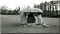
Spinsters' Rock Chambered Tomb
https://www.megalithic.co.uk/article.php?sid=149
Image: © Sandy Gerrard
Taken: Unknown
0.09 miles
9
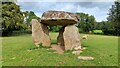
Spinsters Rock
A Neolithic burial chamber dating back to 2500 - 3500 BC. Legend has it that it was built by three spinters one morning before breakfast.
The chamber would have contained many graves and is thought to have been originally covered by a long earth mound.
The stones were re-erected in 1862 after collapsing.
The stones are accessible to the public all the time, with several parking spaces on the nearby lane.
Image: © Mark Percy
Taken: 25 Sep 2022
0.09 miles
10
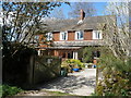
Higher Shilstone Farm
Appears to be constructed almost entirely of wood.
Image: © Roger Cornfoot
Taken: 11 Apr 2009
0.11 miles