IMAGES TAKEN NEAR TO
Chagford, NEWTON ABBOT, TQ13 8JH
Introduction
This page details the photographs taken nearby to TQ13 8JH by members of the Geograph project.
The Geograph project started in 2005 with the aim of publishing, organising and preserving representative images for every square kilometre of Great Britain, Ireland and the Isle of Man.

There are currently over 7.5m images from over14,400 individuals and you can help contribute to the project by visiting https://www.geograph.org.uk
Image Map
Images are licensed for reuse under creativecommons.org/licenses/by-sa/2.0
Notes
- Clicking on the map will re-center to the selected point.
- The higher the marker number, the further away the image location is from the centre of the postcode.
Image Listing (36 Images Found)
Images are licensed for reuse under creativecommons.org/licenses/by-sa/2.0
Image
Details
Distance
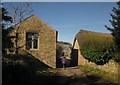
1
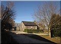
Farm buildings at Yellam
Neat granite barns by the start of Chagford Bridleway 10, which follows the concrete track to the left.
Image: © Derek Harper
Taken: 17 Feb 2013
0.01 miles
2
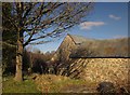
Barns at Yellam
The buildings shown in Image] form a quadrangular farmyard, and these are at the northwest corner, also seen from Chagford Bridleway 10.
Image: © Derek Harper
Taken: 17 Feb 2013
0.02 miles
3
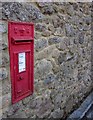
Postbox, Yellam
This Edward VII box, number TQ13 93, is in the wall of the converted barn on the left of Image
Image: © Derek Harper
Taken: 17 Feb 2013
0.03 miles
4
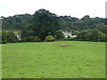
Yellam seen from the valley below
A small group of houses sheltered by trees
Image: © David Smith
Taken: 4 Sep 2018
0.03 miles
5
Buildings at Yellam
The thatched farmhouse on the right is described at http://list.english-heritage.org.uk/resultsingle.aspx?uid=1106165&searchtype=mapsearch as "Probably late C15 or early C16 ... an attractive and interesting farmhouse. It appears to have been converted from a Dartmoor longhouse in the mid C17 and most of the structural detail dates from this time".
Image: © Derek Harper
Taken: 17 Feb 2013
0.03 miles
6
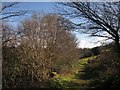
Bridleway to Yellam
Chagford Bridleway 10 approaches the farm. Some of its barns are behind the trees on the left.
Image: © Derek Harper
Taken: 17 Feb 2013
0.06 miles
7
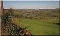
Farmland near Yellam
Looking to the left from the same spot as Image], with overlap. Yellam is mostly hidden on the left; the buildings left of centre are at Great Weeke.
Image: © Derek Harper
Taken: 17 Feb 2013
0.07 miles
8
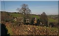
Towards Yellam
Most of the farm buildings at Yellam, behind the tall oak, are in Image and include "an attractive and interesting farmhouse. It appears to have been converted from a Dartmoor longhouse in the mid C17" http://list.english-heritage.org.uk/resultsingle.aspx?uid=1106165&searchtype=mapsearch . This view is from the lane from Middlecott.
Image: © Derek Harper
Taken: 17 Feb 2013
0.08 miles
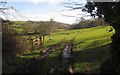
9
Lane at Yellam
Looking away from the farm from the spot where Image] was taken.
Image: © Derek Harper
Taken: 17 Feb 2013
0.08 miles
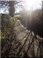
10
Track at Yellam
Image: © Derek Harper
Taken: 17 Feb 2013
0.08 miles