IMAGES TAKEN NEAR TO
Gidleigh, Chagford, NEWTON ABBOT, TQ13 8HU
Introduction
This page details the photographs taken nearby to TQ13 8HU by members of the Geograph project.
The Geograph project started in 2005 with the aim of publishing, organising and preserving representative images for every square kilometre of Great Britain, Ireland and the Isle of Man.

There are currently over 7.5m images from over14,400 individuals and you can help contribute to the project by visiting https://www.geograph.org.uk
Image Map
Images are licensed for reuse under creativecommons.org/licenses/by-sa/2.0
Notes
- Clicking on the map will re-center to the selected point.
- The higher the marker number, the further away the image location is from the centre of the postcode.
Image Listing (30 Images Found)
Images are licensed for reuse under creativecommons.org/licenses/by-sa/2.0
Image
Details
Distance
1
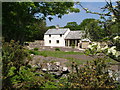
Cottage, Ensworthy
At the edge of the moorland shown in Image, with a garden that had been, at the time this was taken, incorrectly classified as common land (situation since rectified).
Image: © Derek Harper
Taken: 8 Jun 2006
0.00 miles
2
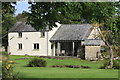
Emsworth Cottage
On the edge of Dartmoor.
Image: © Andrew Abbott
Taken: 23 Sep 2019
0.01 miles
3
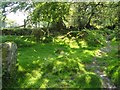
Bridleway near Ensworthy
Gidleigh Bridleway 3 (and the Mariner's Way) enters a patch of woodland beside a tributary (running just this side of the field boundary) of the Forder Brook.
Image: © Derek Harper
Taken: 8 Jun 2006
0.08 miles
4
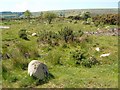
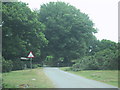
Moorland near Moortown
Another view over the area of roadside moorland shown in Image
Image: © Derek Harper
Taken: 8 Jun 2006
0.08 miles
5
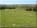
Moorland near Moortown
The unfenced lane past Ensworthy crosses the edge of the open moor. A small tributary of the Forder Brook crosses this area of grass between gorse, with a rockier area beyond. Further off, the land climbs to the smooth outline of Buttern Hill.
Image: © Derek Harper
Taken: 8 Jun 2006
0.11 miles
6
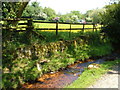
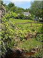
Stream near Ensworthy
Referred to in Image, this tributary of the Forder Brook runs beside Gidleigh Bridleway 3 (and the Mariner's Way) as the two pass through a narrow strip of access land connecting the lanes at Moortown and Aysh. The wall suggests the stream has been controlled, perhaps for use as a leat.
Image: © Derek Harper
Taken: 8 Jun 2006
0.13 miles
7
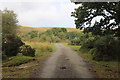
Road at Moortown
Just north of Moortown Farm.
Image: © Andrew Abbott
Taken: 23 Sep 2019
0.13 miles
8
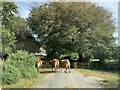
Cows on the road
At Moortown, near Gidleigh.
Image: © Andrew Abbott
Taken: 21 Sep 2019
0.15 miles
10
Donkey's Corner
A cottage glimpsed from Gidleigh Bridleway 3 (and the Mariner's Way) as it runs beside the stream shown in Image
Image: © Derek Harper
Taken: 8 Jun 2006
0.16 miles