IMAGES TAKEN NEAR TO
Gidleigh, Chagford, NEWTON ABBOT, TQ13 8HP
Introduction
This page details the photographs taken nearby to TQ13 8HP by members of the Geograph project.
The Geograph project started in 2005 with the aim of publishing, organising and preserving representative images for every square kilometre of Great Britain, Ireland and the Isle of Man.

There are currently over 7.5m images from over14,400 individuals and you can help contribute to the project by visiting https://www.geograph.org.uk
Image Map
Images are licensed for reuse under creativecommons.org/licenses/by-sa/2.0
Notes
- Clicking on the map will re-center to the selected point.
- The higher the marker number, the further away the image location is from the centre of the postcode.
Image Listing (24 Images Found)
Images are licensed for reuse under creativecommons.org/licenses/by-sa/2.0
Image
Details
Distance
1
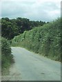
Countryside at Chapple
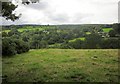
A wider version of the view in Image, taken a little further down the Dartmoor Way (and the Taw-Teign Link) as it follows Throwleigh Bridleway 13; Chapple is to the right. Much gloomier weather, and the trees seem to have grown a bit. Here the valleys of the Moortown Brook and the Forder Brook combine.
Image: © Derek Harper
Taken: 26 Aug 2012
0.07 miles
2
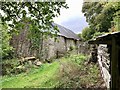
Barn at Coombe Farm
Seen from the Dartmoor Way / Taw-Teign Link following Throwleigh Bridleway 13.
Image: © Derek Harper
Taken: 8 Jun 2006
0.07 miles
5
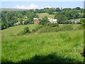
Chapple
A hamlet near Wonson, seen from the Dartmoor Way (and the Taw-Teign Link) as it follows Throwleigh Bridleway 13 between Providence Place and Gidleigh. The moor around Kennon Hill is in the distance.
Image: © Derek Harper
Taken: 8 Jun 2006
0.11 miles
6
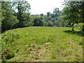
Field by Forder Brook
This grass field runs beside the brook, below on the left. Seen from a gateway on the road between Chapple and Gidleigh Mill, here followed by the Dartmoor Way and Taw-Teign Link.
Image: © Derek Harper
Taken: 8 Jun 2006
0.12 miles
7
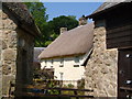
Gidleigh Mill
A glimpse from Gidleigh Byway 5, between the barns shown in Image, of a lovely thatched farmhouse, described at http://list.english-heritage.org.uk/resultsingle.aspx?uid=1147641&searchtype=mapsearch .
Image: © Derek Harper
Taken: 8 Jun 2006
0.14 miles
8
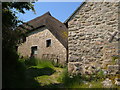
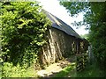
At Gidleigh Mill
Gidleigh Byway 5 climbs past barns, including a fine thatched barn, towards the village of Gidleigh.
Image: © Derek Harper
Taken: 8 Jun 2006
0.15 miles
10
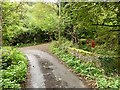
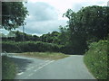
Bridge over Chappel Brook
Near Gidleigh Mill.
Image: © Andrew Abbott
Taken: 23 Sep 2019
0.15 miles