IMAGES TAKEN NEAR TO
Chagford, NEWTON ABBOT, TQ13 8ED
Introduction
This page details the photographs taken nearby to TQ13 8ED by members of the Geograph project.
The Geograph project started in 2005 with the aim of publishing, organising and preserving representative images for every square kilometre of Great Britain, Ireland and the Isle of Man.

There are currently over 7.5m images from over14,400 individuals and you can help contribute to the project by visiting https://www.geograph.org.uk
Image Map
Images are licensed for reuse under creativecommons.org/licenses/by-sa/2.0
Notes
- Clicking on the map will re-center to the selected point.
- The higher the marker number, the further away the image location is from the centre of the postcode.
Image Listing (9 Images Found)
Images are licensed for reuse under creativecommons.org/licenses/by-sa/2.0
Image
Details
Distance
1
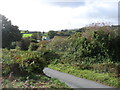
The road to Fernworthy Reservoir
Fernworthy is a popular spot for both anglers and walkers, and so this narrow lane can become very congested in high season.
Image: © David Purchase
Taken: 4 Oct 2019
0.01 miles
2
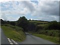
Open land at a junction of minor roads near Meldon Hill
Image: © David Smith
Taken: 3 Aug 2012
0.14 miles
3
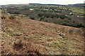
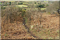
Western slopes below Meldon Hill
Looking left from where Image]; again, beyond the open moor are lines and areas of snow remaining from the heavy falls a few days earlier. On the skyline is Fernworthy Forest.
Image: © Derek Harper
Taken: 6 Mar 2018
0.19 miles
4
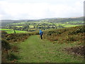
Path down Meldon Hill
Looking in the opposite direction from where Image] to where Image] was taken. Off the open moor, lines of snow linger beside field boundaries. On the skyline to the right is Kestor.
Image: © Derek Harper
Taken: 6 Mar 2018
0.22 miles
6
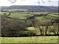
Landscape below Meldon Common
Taken from the same spot as Image, and looking more to the left. Fields drop down to the valley of a tributary of the South Teign River, whose own valley is further off. The left hand fields and the barn in front of the conifers are in SX6885. Once again, Kestor appears on the horizon.
Image: © Derek Harper
Taken: 1 Mar 2008
0.23 miles
7
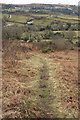
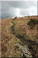
Path through the gorse, Meldon Hill
A tiny path descends the steep western slopes of the hill.
Image: © Derek Harper
Taken: 6 Mar 2018
0.23 miles
8
Path up Meldon Hill
From above where Image] was taken, looking in the opposite direction up the steep slope.
Image: © Derek Harper
Taken: 6 Mar 2018
0.23 miles
9
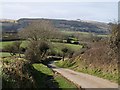
Lane from Corndon
Taken from the same spot as Image, looking down the lane; the junction with the lane to Fernworthy is just round the corner. The woods in the distance are near Frenchbeer in SX6785, on the edge of Chagford Common.
Image: © Derek Harper
Taken: 1 Mar 2008
0.24 miles