IMAGES TAKEN NEAR TO
Chagford, NEWTON ABBOT, TQ13 8DX
Introduction
This page details the photographs taken nearby to TQ13 8DX by members of the Geograph project.
The Geograph project started in 2005 with the aim of publishing, organising and preserving representative images for every square kilometre of Great Britain, Ireland and the Isle of Man.

There are currently over 7.5m images from over14,400 individuals and you can help contribute to the project by visiting https://www.geograph.org.uk
Image Map
Images are licensed for reuse under creativecommons.org/licenses/by-sa/2.0
Notes
- Clicking on the map will re-center to the selected point.
- The higher the marker number, the further away the image location is from the centre of the postcode.
Image Listing (11 Images Found)
Images are licensed for reuse under creativecommons.org/licenses/by-sa/2.0
Image
Details
Distance
1
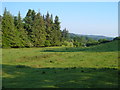
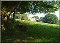
Meadow near Thorn
Looking to the right from the lane shown in Image, with a row of conifers at the edge of the grounds of Torr House.
Image: © Derek Harper
Taken: 8 Jun 2006
0.03 miles
2
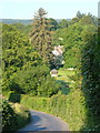
Approaching Thorn
The lane from Waye Cross dips into a valley, with a glimpse of Thorn Farmhouse ahead.
Image: © Derek Harper
Taken: 8 Jun 2006
0.11 miles
3
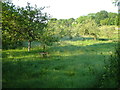
Orchard, Thorn
By the lane near Thorn Cross, with many trees in tree guards.
Image: © Derek Harper
Taken: 8 Jun 2006
0.11 miles
4
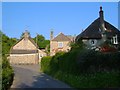
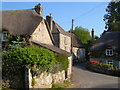
Thorn
A pretty hamlet, also shown in Image The farmhouse on the left has C16 origins http://list.english-heritage.org.uk/resultsingle.aspx?uid=1146736&searchtype=mapsearch ; Thorn Cottage on the right is described at http://list.english-heritage.org.uk/resultsingle.aspx?uid=1106202&searchtype=mapsearch . The cottage in the centre, with a pair of 16-pane sash windows, is described at http://list.english-heritage.org.uk/resultsingle.aspx?uid=1309126&searchtype=mapsearch ; its Victorian post box is just hidden by the hedge.
Image: © Derek Harper
Taken: 8 Jun 2006
0.12 miles
5
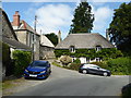
Thorn, near Chagford
A common farm name in these parts. This pretty grouping of cottages is on a small lane near the South Teign southwest of Chagford. Thorn farmhouse is on the left.
Image: © Derek Harper
Taken: 8 Jun 2006
0.12 miles
7
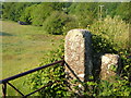
Gateposts near Thorn
Solid granite gateposts by the meadow seen in the foreground of Image
Image: © Derek Harper
Taken: 8 Jun 2006
0.14 miles
8
House near Thorn
Just glimpsed on the left is a water tower dating from 1911 http://list.english-heritage.org.uk/resultsingle.aspx?uid=1326009&searchtype=mapsearch . The buildings, now a pair of cottages, were built as stables and coach house for Outer Down. View from the lane from Thorn.
Image: © Derek Harper
Taken: 8 Jun 2006
0.14 miles
9
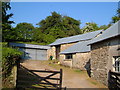
Buildings at Thorn
Farm buildings at the rear of the farmhouse shown in Image, from the lane to Yeo.
Image: © Derek Harper
Taken: 8 Jun 2006
0.18 miles
10
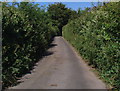
Laneside vegetation
There were more plant species in these hedges than in most well-stocked gardens. I wonder whether these are trimmed by contractor or just by the passing vehicles. This was no place to meet a wide vehicle.
Image: © ian shiell
Taken: 21 Jul 2008
0.21 miles