IMAGES TAKEN NEAR TO
Nattadon Road, NEWTON ABBOT, TQ13 8BE
Introduction
This page details the photographs taken nearby to Nattadon Road, TQ13 8BE by members of the Geograph project.
The Geograph project started in 2005 with the aim of publishing, organising and preserving representative images for every square kilometre of Great Britain, Ireland and the Isle of Man.

There are currently over 7.5m images from over14,400 individuals and you can help contribute to the project by visiting https://www.geograph.org.uk
Image Map
Images are licensed for reuse under creativecommons.org/licenses/by-sa/2.0
Notes
- Clicking on the map will re-center to the selected point.
- The higher the marker number, the further away the image location is from the centre of the postcode.
Image Listing (26 Images Found)
Images are licensed for reuse under creativecommons.org/licenses/by-sa/2.0
Image
Details
Distance
1
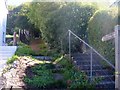
Path meets the road
The footpath ends where it meets Nattadon Road.
Image: © Michael Dibb
Taken: 26 Sep 2018
0.04 miles
2
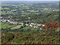
Chagford from Meldon Hill
Housing along Meldon Road and the southeast side of the town, seen past a rowan tree from Meldon Hill. The Teign valley beyond is heading towards the Teign gorge, overlooked by Castle Drogo (right of centre).
Image: © Derek Harper
Taken: 3 Sep 2009
0.06 miles
3
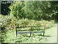
Seat without a view
The seat is alongside the steep path from the top of Nattadon Common to Meldon Road. Probably of more use to those walkers ascending the path rather than those descending. There probably was a view when the seat was erected before the trees grew.
Image: © Michael Dibb
Taken: 26 Sep 2018
0.09 miles
5
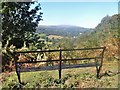
Seat with a view
The seat is alongside the steep path from the top of Nattadon Common to Meldon Road. Probably of more use to those walkers ascending the path rather than those descending.
Image: © Michael Dibb
Taken: 26 Sep 2018
0.11 miles
6
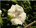
Great Bindweed near Chagford
Calystegia sepium - a bloom seen from the rear, showing the bracts enclosing the base of the large flower. Squeeze this and you have "granny pop out of bed", as I learned to call it as a child. Amazing how some of the most spectacular wildflowers are also virulent garden weeds - dandelion is another example.
Image: © Derek Harper
Taken: 20 Jul 2008
0.13 miles
7
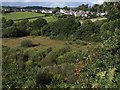
Padley Common
Seen from a path descending Meldon Hill. "Padley Common is a 13 hectare area of land owned by the parish council and forms part of Chagford Commons. It is an area of purple moor grass and rush pasture and provides important habitats for many species, including the marsh fritilliary butterfly, the reed bunting and woodcock and is grazed by cattle and Dartmoor ponies." http://www.gov-news.org/gov/uk/news/natural_england_supports_community_action/52318.html
Above, beside Chagford Open Field (see Image), is housing on New Street, Chagford.
Image: © Derek Harper
Taken: 3 Sep 2009
0.14 miles
8
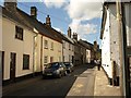
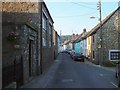
New Street, Chagford
New Street leads northwards between old houses towards the town centre.
Image: © Derek Harper
Taken: 20 Jul 2008
0.16 miles
9
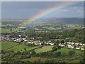
Rainbow over Chagford
Housing on New Street and Meldon Road, taken from the same spot on Meldon Hill as Image The main rainbow shown in Image has waned and then brightened again. Below the arc to right of centre can be seen Castle Drogo.
Image: © Derek Harper
Taken: 3 Sep 2009
0.17 miles
10
New Street, Chagford
At the junction with the turning on the right where Image was taken. The terrace then continues for nearly 100 metres.
Image: © Derek Harper
Taken: 8 Jun 2006
0.18 miles