IMAGES TAKEN NEAR TO
Widecombe-in-the-Moor, NEWTON ABBOT, TQ13 7TR
Introduction
This page details the photographs taken nearby to TQ13 7TR by members of the Geograph project.
The Geograph project started in 2005 with the aim of publishing, organising and preserving representative images for every square kilometre of Great Britain, Ireland and the Isle of Man.

There are currently over 7.5m images from over14,400 individuals and you can help contribute to the project by visiting https://www.geograph.org.uk
Image Map
Images are licensed for reuse under creativecommons.org/licenses/by-sa/2.0
Notes
- Clicking on the map will re-center to the selected point.
- The higher the marker number, the further away the image location is from the centre of the postcode.
Image Listing (13 Images Found)
Images are licensed for reuse under creativecommons.org/licenses/by-sa/2.0
Image
Details
Distance
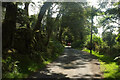
1
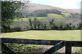
View near Pitton
From the Widecombe to Natsworthy Lane. Looking west over Pitton towards Pitton Brake (woodland) and the moorland of Hameldown.
Image: © Graham Horn
Taken: 12 Apr 2013
0.12 miles
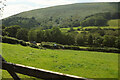
2
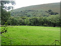
Valley Bottom Pasture
This pasture land is being used to graze horses (although there are none in the photo). It seems to be the trend these day, first they want a house in the country, then they want a horse.
Image: © Tony Atkin
Taken: 21 Aug 2012
0.13 miles
3
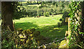
Cattle near Pitton
From the Two Moors Way south of Isaford.
Image: © Derek Harper
Taken: 27 Aug 2021
0.15 miles
6
East Webburn valley at Pitton
From the lane carrying the Two Moors Way south of isaford. Behind rises Hamel Down.
Image: © Derek Harper
Taken: 27 Aug 2021
0.19 miles
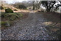
7
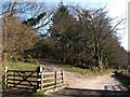
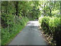
Track and lane near Pitton
Across the cattle grid, a steep track leaves the lane to Widecombe and climbs around a plantation towards Bonehill Down.
Image: © Derek Harper
Taken: 1 Apr 2009
0.21 miles
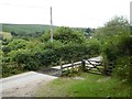
8

Cattle Grid
On the road between Widecombe in the Moor and Natsworthy.
Image: © jeff collins
Taken: 18 Mar 2015
0.21 miles
10
Public access route to Bonehill Down
Passing below Honeybag Tor and Chinkwell Tor on the way.
Image: © jeff collins
Taken: 18 Mar 2015
0.22 miles