IMAGES TAKEN NEAR TO
Widecombe-in-the-Moor, NEWTON ABBOT, TQ13 7TH
Introduction
This page details the photographs taken nearby to TQ13 7TH by members of the Geograph project.
The Geograph project started in 2005 with the aim of publishing, organising and preserving representative images for every square kilometre of Great Britain, Ireland and the Isle of Man.

There are currently over 7.5m images from over14,400 individuals and you can help contribute to the project by visiting https://www.geograph.org.uk
Image Map
Images are licensed for reuse under creativecommons.org/licenses/by-sa/2.0
Notes
- Clicking on the map will re-center to the selected point.
- The higher the marker number, the further away the image location is from the centre of the postcode.
Image Listing (14 Images Found)
Images are licensed for reuse under creativecommons.org/licenses/by-sa/2.0
Image
Details
Distance
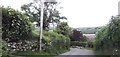
2
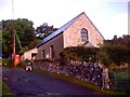
Dunstone Methodist Chapel
About 1 km south of Widecombe in the Moor. A small chapel with later rear addition of modern toilet/kitchen, but no link between the two! The telephone box is no longer connected but appears on the map.
Image: © Trevor Chapman
Taken: 24 Sep 2005
0.03 miles
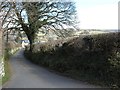
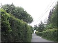
3
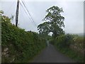
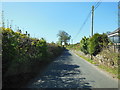
Take care when passing these walls
In common with many walls on Dartmoor roads, these are covered with green growth. Drivers who fail to realise that the apparent "hedge" is lined with stone are apt to damage their cars if they come too close. This is the road between Great Dunstone and Widecombe in the Moor
Image: © David Smith
Taken: 30 May 2014
0.04 miles
8
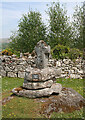
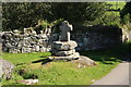
Dunstone Wayside Cross, Lower Dunstone, Widecombe in the Moor
Dunstone Cross, old head, shaft and base, Starkey No.108 by the UC road, in parish of Widecombe in the Moor (Teignbridge District), Lower Dunstone Village Green, near Dunstone House, on a pile of large stones.
For other views, see: https://www.flickr.com/photos/tollhouses/4639348140/in/photolist-84XSz3-84XS9q-84UHC6
Grade II Listed.
List Entry Number: 1241678 https://historicengland.org.uk/listing/the-list/list-entry/1241678
Surveyed
Milestone Society National ID: DVTE_WID05
Image: © Alan Rosevear
Taken: 25 May 2010
0.17 miles
9
Dunstone Cross
The plate on the base states " Dunstone Cross back in its original site after 100 years in the vicarage garden. Restored by Miss M Hamlyn Dunstone Manor 1980.
Image: © Guy Wareham
Taken: 9 Sep 2009
0.18 miles
10
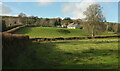
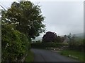
Lower Dunstone
From a gate seen past the bridge in Image Just the roof of the listed farmhouse https://historicengland.org.uk/listing/the-list/list-entry/1260216 left of centre can be seen. Similarly, the hillside hides most of Dunstone Manor https://historicengland.org.uk/listing/the-list/list-entry/1241688 on the left.
Image: © Derek Harper
Taken: 19 Nov 2020
0.19 miles