IMAGES TAKEN NEAR TO
Widecombe-in-the-Moor, NEWTON ABBOT, TQ13 7TF
Introduction
This page details the photographs taken nearby to TQ13 7TF by members of the Geograph project.
The Geograph project started in 2005 with the aim of publishing, organising and preserving representative images for every square kilometre of Great Britain, Ireland and the Isle of Man.

There are currently over 7.5m images from over14,400 individuals and you can help contribute to the project by visiting https://www.geograph.org.uk
Image Map
Images are licensed for reuse under creativecommons.org/licenses/by-sa/2.0
Notes
- Clicking on the map will re-center to the selected point.
- The higher the marker number, the further away the image location is from the centre of the postcode.
Image Listing (6 Images Found)
Images are licensed for reuse under creativecommons.org/licenses/by-sa/2.0
Image
Details
Distance
1
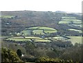
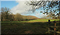
East Webburn valley from Dunstone Down
Looking down from the edge of the open moor on Dunstone Down. The river is hidden in the bottom half of the photo. The buildings (Little Meadow in the centre, and Venton on the extreme right) are in Image, on the lane between Widecombe and Chittleford. Beyond the distinctive semi-circle of fields, moorland rises towards Top Tor and Pil Tor, with Rippon Tor just appearing above the horizon.
Image: © Derek Harper
Taken: 2 Feb 2008
0.18 miles
2
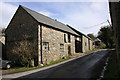
Shilstone Rocks Riding Centre
Part of a large riding centre and stud.
Image: © Guy Wareham
Taken: 31 Mar 2010
0.20 miles
3
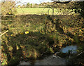
Stream near Chittleford
Running beside the lane shown in Image
Image: © Derek Harper
Taken: 19 Nov 2020
0.21 miles
4
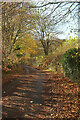
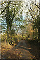
Autumn lane near Chittleford
The lane curves towards the bridge where Image] was taken.
Image: © Derek Harper
Taken: 19 Nov 2020
0.23 miles
5
Field by the East Webburn
Looking right from the gate visible in Image In the distance is Hamel Down.
Image: © Derek Harper
Taken: 19 Nov 2020
0.23 miles
6
Lane to Chittleford
Crossing the valley of the East Webburn.
Image: © Derek Harper
Taken: 19 Nov 2020
0.24 miles